IMAGES TAKEN NEAR TO
High Street, LLANGADOG, SA19 9EF
Introduction
This page details the photographs taken nearby to High Street, SA19 9EF by members of the Geograph project.
The Geograph project started in 2005 with the aim of publishing, organising and preserving representative images for every square kilometre of Great Britain, Ireland and the Isle of Man.

There are currently over 7.5m images from over14,400 individuals and you can help contribute to the project by visiting https://www.geograph.org.uk
Image Map
Images are licensed for reuse under creativecommons.org/licenses/by-sa/2.0
Notes
- Clicking on the map will re-center to the selected point.
- The higher the marker number, the further away the image location is from the centre of the postcode.
Image Listing (67 Images Found)
Images are licensed for reuse under creativecommons.org/licenses/by-sa/2.0
Image
Details
Distance
1
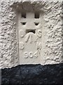
Ordnance Survey Flush Bracket (904)
This OS Flush Bracket (904) can be found on what were the stables of the Bear Inn, Llangadog. It was used during the Second Geodetic Levelling of England & Wales (1912-21) Carmarthen - Llandovery Levelling Line. Also the Third Geodetic Levelling of England & Wales (1950-68) Llandovery - Carmarthen Levelling Line. It marks a point 177.4540ft above mean sea level.
Image: © Adrian Dust
Taken: 2 Jun 2013
0.01 miles
2
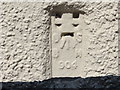
Ordnance Survey Flush Bracket 904
This can be found on the wall of a private dwelling in Llangadog.
For more detail see : http://www.bench-marks.org.uk/bm10019
Image: © Peter Wood
Taken: 20 Apr 2015
0.01 miles
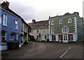
3
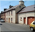
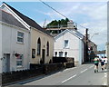
High Street houses, Llangadog
Looking towards Queen's Square and the Black Lion pub. http://www.geograph.org.uk/photo/2516290
Image: © Jaggery
Taken: 3 Jul 2011
0.03 miles
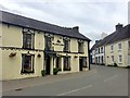
4
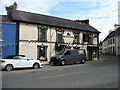
The Black Lion, Llangadog
This pub has closed, and is in the process of being converted to a private residence. But the Red Lion, a few doors away to the left, remains open.
Image: © David Purchase
Taken: 4 Sep 2018
0.03 miles
6
The Black Lion
The Black Lion, Llangadog.
Image: © Alan Hughes
Taken: 15 Aug 2019
0.04 miles
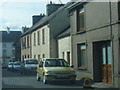
8
Centre of Llangadog
A relatively vast expanse of tarmac occurs in the middle of Llangadog - the result of three very narrow roads joining in one place.
Image: © Nigel Davies
Taken: 25 Feb 2007
0.04 miles
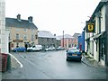
9
Sunday joggers, Llangadog
Joggers pass the former Seion Chapel http://www.geograph.org.uk/photo/3331883 on the left.
Image: © Jaggery
Taken: 3 Jul 2011
0.04 miles
10
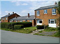
Heol Pendref houses, Llangadog
Viewed from the corner of Golwg-y-mynydd http://www.geograph.org.uk/photo/2516564 looking towards the A4069.
Image: © Jaggery
Taken: 3 Jul 2011
0.05 miles