IMAGES TAKEN NEAR TO
LLANGADOG, SA19 9BB
Introduction
This page details the photographs taken nearby to SA19 9BB by members of the Geograph project.
The Geograph project started in 2005 with the aim of publishing, organising and preserving representative images for every square kilometre of Great Britain, Ireland and the Isle of Man.

There are currently over 7.5m images from over14,400 individuals and you can help contribute to the project by visiting https://www.geograph.org.uk
Image Map
Images are licensed for reuse under creativecommons.org/licenses/by-sa/2.0
Notes
- Clicking on the map will re-center to the selected point.
- The higher the marker number, the further away the image location is from the centre of the postcode.
Image Listing (4 Images Found)
Images are licensed for reuse under creativecommons.org/licenses/by-sa/2.0
Image
Details
Distance
1
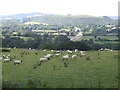
The Towy valley
View from south to north; the Tirley gas pipeline makes a grey scar across the greenery.
Image: © Jonathan Billinger
Taken: 9 Aug 2007
0.13 miles
2

Llwybr ger Tylau Hywel / Path near Tylau Hywel
Llwybr troed cyhoeddus yn gadael heol fach ger Tylau Hywel.
A public footpath exits a minor road near Tylau Hywel (trans. Hywels' ?slopes).
Image: © Alan Richards
Taken: 17 Jan 2022
0.20 miles
3
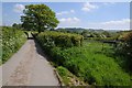
Country road and field gateway
Country road and field gateway near Cynyll Farm.
Image: © Philip Halling
Taken: 18 May 2014
0.23 miles
4
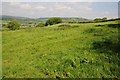
Farmland above the Twyi valley
Farmland above the Twyi valley near Cynyll Farm.
Image: © Philip Halling
Taken: 18 May 2014
0.25 miles