IMAGES TAKEN NEAR TO
Castle Close, LLANGADOG, SA19 9AH
Introduction
This page details the photographs taken nearby to Castle Close, SA19 9AH by members of the Geograph project.
The Geograph project started in 2005 with the aim of publishing, organising and preserving representative images for every square kilometre of Great Britain, Ireland and the Isle of Man.

There are currently over 7.5m images from over14,400 individuals and you can help contribute to the project by visiting https://www.geograph.org.uk
Image Map
Images are licensed for reuse under creativecommons.org/licenses/by-sa/2.0
Notes
- Clicking on the map will re-center to the selected point.
- The higher the marker number, the further away the image location is from the centre of the postcode.
Image Listing (60 Images Found)
Images are licensed for reuse under creativecommons.org/licenses/by-sa/2.0
Image
Details
Distance
1
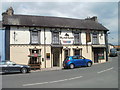
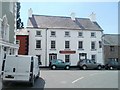
Black Lion, Llangadog
Located in Queen's Square.
Its blue-painted neighbour on the left is the Goose & Cuckoo. http://www.geograph.org.uk/photo/2516272
Image: © Jaggery
Taken: 3 Jul 2011
0.02 miles
2
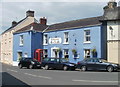
Goose & Cuckoo, Llangadog
Previously named the Carpenters Arms, the pub is located in Queen's Square, next door to the Black Lion. http://www.geograph.org.uk/photo/2516290
The red phonebox was Grade II listed in April 2006.
Image: © Jaggery
Taken: 3 Jul 2011
0.02 miles
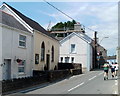
3
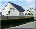
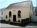
Two-tone Community Centre, Llangadog
Llangadog Community Centre is set back from the west side of the A4069,
to the south of the centre of the village.
Image: © Jaggery
Taken: 3 Jul 2011
0.03 miles
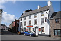
4
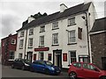
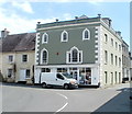
Gwesty'r Castell
The Castle Hotel in Queen Square, Llangadog.
Image: © Alan Hughes
Taken: 24 Aug 2017
0.04 miles
5
Former Seion Baptist Chapel, Llangadog
Viewed across the A4069 to the south of Queen's Square. The inscription (in Welsh) on the plaque on the wall shows that the chapel was built in 1808, rebuilt in 1886.
Image: © Jaggery
Taken: 3 Jul 2011
0.04 miles
6
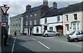
Llangadog : A4069 approaches Queen's Square from the south
Looking towards Queen's Square at the junction of High Street and Church Street.
Image: © Jaggery
Taken: 3 Jul 2011
0.04 miles
7
The Limes, Llangadog
Located on the SE corner of Queen's Square, facing the Black Lion. http://www.geograph.org.uk/photo/2516290
Originally two buildings, this late Georgian (c late 18th - early 19th century) townhouse retains a distinctively different appearance for the north and south sides. The south side (glimpsed at the right edge of the view) is residential, whereas the ground floor of the north side, seen here, is a general store.
The Limes was Grade II listed in August 1966.
Image: © Jaggery
Taken: 3 Jul 2011
0.04 miles
8
Gwesty'r Castell (Castle Hotel), Llangadog
Pub and B&B (bed and breakfast accommodation), Queen's Square.
Based on the conversations I heard in the area, Welsh appears to be the main language of everyday use in this part of rural Carmarthenshire, and explains the prominence given to the Welsh form of the name, twice the size of the English version underneath it on the dark red name board.
The building at the left edge of the view is the Grade II listed The Limes. http://www.geograph.org.uk/photo/2516321
Image: © Jaggery
Taken: 3 Jul 2011
0.04 miles
9
Gwesty'r Castell, Llangadog
The Gwesty'r Castell or Castle Hotel in Llangadog.
Image: © Philip Halling
Taken: 13 May 2012
0.04 miles
10
Sunday joggers, Llangadog
Joggers pass the former Seion Chapel http://www.geograph.org.uk/photo/3331883 on the left.
Image: © Jaggery
Taken: 3 Jul 2011
0.04 miles