IMAGES TAKEN NEAR TO
Church Street, LLANGADOG, SA19 9AA
Introduction
This page details the photographs taken nearby to Church Street, SA19 9AA by members of the Geograph project.
The Geograph project started in 2005 with the aim of publishing, organising and preserving representative images for every square kilometre of Great Britain, Ireland and the Isle of Man.

There are currently over 7.5m images from over14,400 individuals and you can help contribute to the project by visiting https://www.geograph.org.uk
Image Map
Images are licensed for reuse under creativecommons.org/licenses/by-sa/2.0
Notes
- Clicking on the map will re-center to the selected point.
- The higher the marker number, the further away the image location is from the centre of the postcode.
Image Listing (63 Images Found)
Images are licensed for reuse under creativecommons.org/licenses/by-sa/2.0
Image
Details
Distance
1
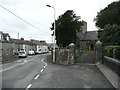
Entrance to the churchyard, Llangadog
Image: © Humphrey Bolton
Taken: 27 Apr 2019
0.01 miles
2
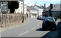
A4069 road sign, Llangadog
I was confused when I saw this road sign in Church Street. I was already on the A4069,
so wondered how both arms of the junction ahead were also the A4069.
The sign is correct. The explanation is that this part of the A4069 is a spur
(Church Street and Station Road) through Llangadog to the A40.
The main route of the A4069 is ahead.
Image: © Jaggery
Taken: 3 Jul 2011
0.01 miles
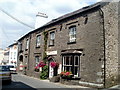
3
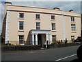
Grade II* listed Church House, Llangadog
Located in Church Street adjacent to the southern entrance to St Cadoc's churchyard.
The 3-storey house was built in the 18th century in a typical Georgian style.
Grade II* listed in August 1966.
Image: © Jaggery
Taken: 3 Jul 2011
0.02 miles
4
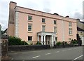
Georgian Town House
Georgian Town House in Church Street, Llangadog.
Image: © Alan Hughes
Taken: 15 Aug 2019
0.02 miles
5
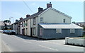
Church Street houses, Llangadog
Viewed across Church Street past the corner of Vicarage Road.
Image: © Jaggery
Taken: 3 Jul 2011
0.03 miles
6
The Red Lion Coaching Inn, Llangadog
Located on the east side of Church Street, The Red Lion is part of the privately owned Cariad Inns Group which also owns The Kings Head http://www.geograph.org.uk/photo/3185830 in Llandovery and The Lamb & Flag http://www.geograph.org.uk/photo/3015809 in Rhayader.
Image: © Jaggery
Taken: 3 Jul 2011
0.03 miles
7
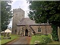
St Cadog Church
St Cadog Church, Llangadog.
Image: © Alan Hughes
Taken: 15 Aug 2019
0.03 miles
9
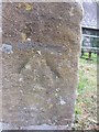
Ordnance Survey Cut Mark
This OS cut mark can be found on the SW angle, W face of St Cadog's Church. It marks a point 48.4240m above mean sea level.
Image: © Adrian Dust
Taken: 18 Aug 2013
0.03 miles
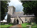
10
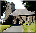
South side of St Cadog Parish Church, Llangadog
The name of the village, Llangadog, means the area around (the church of) Cadog. There has been a church on this site since the 7th century. The tower was a 14th century addition. The present-day church is mostly the result of an extensive restoration and partial rebuild in 1889.
Image: © Jaggery
Taken: 3 Jul 2011
0.04 miles