IMAGES TAKEN NEAR TO
Caio, LLANWRDA, SA19 8RN
Introduction
This page details the photographs taken nearby to SA19 8RN by members of the Geograph project.
The Geograph project started in 2005 with the aim of publishing, organising and preserving representative images for every square kilometre of Great Britain, Ireland and the Isle of Man.

There are currently over 7.5m images from over14,400 individuals and you can help contribute to the project by visiting https://www.geograph.org.uk
Image Map
Images are licensed for reuse under creativecommons.org/licenses/by-sa/2.0
Notes
- Clicking on the map will re-center to the selected point.
- The higher the marker number, the further away the image location is from the centre of the postcode.
Image Listing (3 Images Found)
Images are licensed for reuse under creativecommons.org/licenses/by-sa/2.0
Image
Details
Distance
1
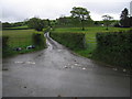
Llwybr yn gadael yr heol / Path exits the road
Llwybr cyhoeddus yn gadael yr heol ger pentre Caio. Ar adeg ysgrifennu hwn mae'r llwybr wedi ei rwystro.
A public footpath exits the road near the village of Caio. At the time of writing the footpath is obstructed.
Image: © Alan Richards
Taken: 31 Jul 2022
0.17 miles
2
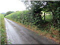
Winding up the hill
A delightful lane winds its way up the hillside, and rain pours down it.
Image: © Neville Goodman
Taken: 18 May 2009
0.20 miles