IMAGES TAKEN NEAR TO
Ffaldybrenin, LLANWRDA, SA19 8QF
Introduction
This page details the photographs taken nearby to Ffaldybrenin, SA19 8QF by members of the Geograph project.
The Geograph project started in 2005 with the aim of publishing, organising and preserving representative images for every square kilometre of Great Britain, Ireland and the Isle of Man.

There are currently over 7.5m images from over14,400 individuals and you can help contribute to the project by visiting https://www.geograph.org.uk
Image Map (Loading...)


Getting Data...Please wait
Leaflet Map data © OpenStreetMap
Images are licensed for reuse under creativecommons.org/licenses/by-sa/2.0
Notes
- Clicking on the map will re-center to the selected point.
- The higher the marker number, the further away the image location is from the centre of the postcode.
Image Listing (7 Images Found)
Images are licensed for reuse under creativecommons.org/licenses/by-sa/2.0
Image
Details
Distance
1
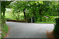
Road junction by the bridge
The bridge over the Camnant can be seen on the left.
Image: © Nigel Brown
Taken: 21 May 2008
0.09 miles
2
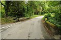
Country road and bridge
Country road and bridge crossing a stream to the west of Ffaldybrenin.
Image: © Philip Halling
Taken: 20 Sep 2015
0.10 miles
3
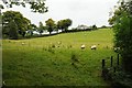
Field below Wernlwyd
Field below Wernlwyd to the west of Ffaldybrenin.
Image: © Philip Halling
Taken: 20 Sep 2015
0.11 miles
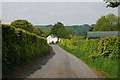
4
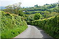
Descending road
Once near the entrance to Gelli farm the gradient on this road eases, but it is still steep.
Image: © Nigel Brown
Taken: 21 May 2008
0.17 miles
5
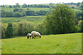
Field above the Nant y Blaenau
Serious eating in progress.
Image: © Nigel Brown
Taken: 21 May 2008
0.21 miles
6
Road approaching Erwion farm
The farm can be seen ahead.
Image: © Nigel Brown
Taken: 21 May 2008
0.24 miles
7
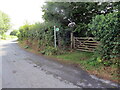
Llwybr yn gadael yr heol / Path exits the road
Llwybr cyhoeddus yn gadael yr heol ger Ffaldybrenin.
A public footpath exits the road near Ffaldybrenin (trans. the king's [animal] pound).
Image: © Alan Richards
Taken: 26 Aug 2022
0.24 miles