IMAGES TAKEN NEAR TO
Caio, LLANWRDA, SA19 8PW
Introduction
This page details the photographs taken nearby to SA19 8PW by members of the Geograph project.
The Geograph project started in 2005 with the aim of publishing, organising and preserving representative images for every square kilometre of Great Britain, Ireland and the Isle of Man.

There are currently over 7.5m images from over14,400 individuals and you can help contribute to the project by visiting https://www.geograph.org.uk
Image Map (Loading...)


Getting Data...Please wait
Leaflet Map data © OpenStreetMap
Images are licensed for reuse under creativecommons.org/licenses/by-sa/2.0
Notes
- Clicking on the map will re-center to the selected point.
- The higher the marker number, the further away the image location is from the centre of the postcode.
Image Listing (2 Images Found)
Images are licensed for reuse under creativecommons.org/licenses/by-sa/2.0
Image
Details
Distance
1
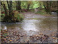
Rhyd Afon Dulais Ford
Rhyd ger Aberbowlan. Enw'r afon yw Dulais. Mae'r heol yn dringo i fyny at Fanc Bedw Gleision cyn disgyn i bentre Porthyrhyd.
A ford near Aberbowlan. The name of the river is the Dulais (trans. Black Stream). The road climbs up to Banc Bedw Gleision (trans. Hill of Green Birches) to a village called Porthyrhyd (trans. Ford Gate).
Image: © Alan Richards
Taken: 4 Nov 2011
0.07 miles
2
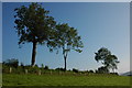
Trees in a hedgerow
Trees in a hedgerow near the village of Caio.
Image: © Philip Halling
Taken: 21 Sep 2008
0.21 miles