IMAGES TAKEN NEAR TO
Ffarmers, LLANWRDA, SA19 8NQ
Introduction
This page details the photographs taken nearby to SA19 8NQ by members of the Geograph project.
The Geograph project started in 2005 with the aim of publishing, organising and preserving representative images for every square kilometre of Great Britain, Ireland and the Isle of Man.

There are currently over 7.5m images from over14,400 individuals and you can help contribute to the project by visiting https://www.geograph.org.uk
Image Map (Loading...)


Getting Data...Please wait
Leaflet Map data © OpenStreetMap
Images are licensed for reuse under creativecommons.org/licenses/by-sa/2.0
Notes
- Clicking on the map will re-center to the selected point.
- The higher the marker number, the further away the image location is from the centre of the postcode.
Image Listing (4 Images Found)
Images are licensed for reuse under creativecommons.org/licenses/by-sa/2.0
Image
Details
Distance
1
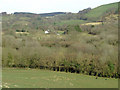
Farmland near Ffarmers, Carmarthenshire
Looking across the valley of the Afon Twrch.
Image: © Roger D Kidd
Taken: 16 Mar 2009
0.11 miles
3

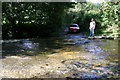
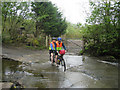
Road leading to ford
Best avoided except in drought conditions; rivers here rise quickly in wet weather.
Image: © Nigel Brown
Taken: 24 Sep 2010
0.17 miles