IMAGES TAKEN NEAR TO
Llansadwrn, LLANWRDA, SA19 8NB
Introduction
This page details the photographs taken nearby to SA19 8NB by members of the Geograph project.
The Geograph project started in 2005 with the aim of publishing, organising and preserving representative images for every square kilometre of Great Britain, Ireland and the Isle of Man.

There are currently over 7.5m images from over14,400 individuals and you can help contribute to the project by visiting https://www.geograph.org.uk
Image Map (Loading...)


Getting Data...Please wait
Leaflet Map data © OpenStreetMap
Images are licensed for reuse under creativecommons.org/licenses/by-sa/2.0
Notes
- Clicking on the map will re-center to the selected point.
- The higher the marker number, the further away the image location is from the centre of the postcode.
Image Listing (4 Images Found)
Images are licensed for reuse under creativecommons.org/licenses/by-sa/2.0
Image
Details
Distance
1
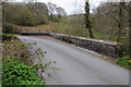
Bridge over Afon Marlais
Bridge over Afon Marlais to the west of Llansadwrn.
Image: © Philip Halling
Taken: 5 May 2013
0.02 miles
2
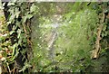
Ordnance Survey Cut Mark
This OS cut mark can be found on the garage next to the bridge. It marks a point 98.214m above mean sea level.
Image: © Adrian Dust
Taken: 27 Oct 2016
0.03 miles
3
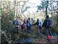
Ger Llwyn y Bwch / Near Llwyn y Bwch
Cerddwyr yn croesi pontdroed sy'n rhychwantu Afon Marlais ger Ffarm Llwyn y Bwch. .
Walkers crossing a footbridge spanning the Marlais River near Llwyn y Bwch Farm (trans. buck grove).
Image: © Alan Richards
Taken: 2 Jan 2005
0.19 miles
4
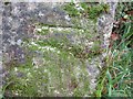
Ordnance Survey Cut Mark
This OS cut mark can be found on the milk stand at Tirsiencyn Farm. It marks a point 119.609m above mean sea level.
Image: © Adrian Dust
Taken: 27 Oct 2016
0.22 miles