IMAGES TAKEN NEAR TO
Ffarmers, LLANWRDA, SA19 8JE
Introduction
This page details the photographs taken nearby to SA19 8JE by members of the Geograph project.
The Geograph project started in 2005 with the aim of publishing, organising and preserving representative images for every square kilometre of Great Britain, Ireland and the Isle of Man.

There are currently over 7.5m images from over14,400 individuals and you can help contribute to the project by visiting https://www.geograph.org.uk
Image Map (Loading...)


Getting Data...Please wait
Leaflet Map data © OpenStreetMap
Images are licensed for reuse under creativecommons.org/licenses/by-sa/2.0
Notes
- Clicking on the map will re-center to the selected point.
- The higher the marker number, the further away the image location is from the centre of the postcode.
Image Listing (10 Images Found)
Images are licensed for reuse under creativecommons.org/licenses/by-sa/2.0
Image
Details
Distance
1
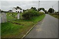
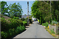
Road passing through Ffarmers
Country road passing through the village of Ffarmers, sheep can be seen grazing in the field on the left.
Image: © Philip Halling
Taken: 20 Sep 2015
0.02 miles
2
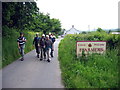
Ffarmers
Cerddwyr yn gadael pentre Ffarmers.
Walkers leaving the village of Ffarmers.
Image: © Alan Richards
Taken: 12 Jun 2005
0.07 miles
3

Sunset over Ffarmers
Taken from near Bwlchgwynt, Blaunau and Garth are the nearest buildings in view.
As with some of my others, this is an HDR image; my aim with these is to reproduce as near as I can what the scene looked like to the naked eye.
Image: © Austin Shackles
Taken: 1 Mar 2010
0.08 miles
4
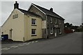
Drovers Arms, Ffarmers
The Drovers Arms in the village of Ffarmers. With the Rugby World Cup on at present the board is promoting forthcoming televised games.
Image: © Philip Halling
Taken: 20 Sep 2015
0.08 miles
6
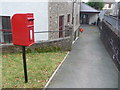
Ffarmers: postbox № SA19 452
This postbox is in the grounds of Image, which hosts the post office through the door by the sign. It is emptied finally at 3:45pm on weekdays and at 11:30am on Saturdays.
Image: © Chris Downer
Taken: 23 Feb 2009
0.13 miles
7
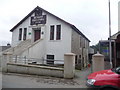
Ffarmers: the village hall
On weekday mornings, the post office is open within the village hall, hence the sign on the pathway. Behind the left-hand gatepost is the postbox; the postman has just stopped to pick up the day's post and we can see the bonnet of his van.
Image: © Chris Downer
Taken: 23 Feb 2009
0.13 miles
8
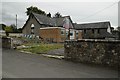
Main road, Ffarmers
Unlike most villages around here, houses in Ffarmers are fairly spread out, except for those just by the cross roads in the distance. The road here lies along the line of Sarn Helen Roman road.
Image: © Nigel Brown
Taken: 13 May 2008
0.17 miles
9
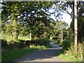
Lane leading east from Ffarmers village
Image: © Roger Butler
Taken: 29 Aug 2007
0.20 miles
10
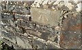
Ordnance Survey Cut Mark
This OS cut mark can be found on the north parapet of the bridge. It marks a point 164.141m above mean sea level.
Image: © Adrian Dust
Taken: 4 Dec 2016
0.22 miles