IMAGES TAKEN NEAR TO
Ffarmers, LLANWRDA, SA19 8HJ
Introduction
This page details the photographs taken nearby to SA19 8HJ by members of the Geograph project.
The Geograph project started in 2005 with the aim of publishing, organising and preserving representative images for every square kilometre of Great Britain, Ireland and the Isle of Man.

There are currently over 7.5m images from over14,400 individuals and you can help contribute to the project by visiting https://www.geograph.org.uk
Image Map (Loading...)


Getting Data...Please wait
Leaflet Map data © OpenStreetMap
Images are licensed for reuse under creativecommons.org/licenses/by-sa/2.0
Notes
- Clicking on the map will re-center to the selected point.
- The higher the marker number, the further away the image location is from the centre of the postcode.
Image Listing (2 Images Found)
Images are licensed for reuse under creativecommons.org/licenses/by-sa/2.0
Image
Details
Distance
1
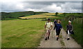
Llwybr Blaenau / Blaenau path
Cerddwyr yn dilyn llwybr cyhoeddus i lawr o'r ucheldir tuag at Ffarm y Blaenau.
Walkers following a public path down from the hills in the direction of Blaenau Farm (trans. uplands)
Image: © Alan Richards
Taken: 12 Jun 2005
0.13 miles
2
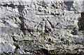
Ordnance Survey Cut Mark
This OS cut mark can be found on the roadside barn at Blaenau Farm . It marks a point 254.078m above mean sea level.
Image: © Adrian Dust
Taken: 2 Jul 2017
0.18 miles