IMAGES TAKEN NEAR TO
LLANWRDA, SA19 8ER
Introduction
This page details the photographs taken nearby to SA19 8ER by members of the Geograph project.
The Geograph project started in 2005 with the aim of publishing, organising and preserving representative images for every square kilometre of Great Britain, Ireland and the Isle of Man.

There are currently over 7.5m images from over14,400 individuals and you can help contribute to the project by visiting https://www.geograph.org.uk
Image Map
Images are licensed for reuse under creativecommons.org/licenses/by-sa/2.0
Notes
- Clicking on the map will re-center to the selected point.
- The higher the marker number, the further away the image location is from the centre of the postcode.
Image Listing (2 Images Found)
Images are licensed for reuse under creativecommons.org/licenses/by-sa/2.0
Image
Details
Distance
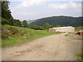
2
Livestock pens
These livestock pens are marked on the large scale OS map as 'Sheep dip'. A sheep dip is used for 'dipping' sheep, basically a narrow tank dug into the ground filled with a diluted liquid formulation of insecticide and fungicide which protect sheep from parasites such as flies laying eggs in their wool.
Image: © Philip Halling
Taken: 5 May 2013
0.19 miles