IMAGES TAKEN NEAR TO
Pumpsaint, LLANWRDA, SA19 8EJ
Introduction
This page details the photographs taken nearby to SA19 8EJ by members of the Geograph project.
The Geograph project started in 2005 with the aim of publishing, organising and preserving representative images for every square kilometre of Great Britain, Ireland and the Isle of Man.

There are currently over 7.5m images from over14,400 individuals and you can help contribute to the project by visiting https://www.geograph.org.uk
Image Map
Images are licensed for reuse under creativecommons.org/licenses/by-sa/2.0
Notes
- Clicking on the map will re-center to the selected point.
- The higher the marker number, the further away the image location is from the centre of the postcode.
Image Listing (6 Images Found)
Images are licensed for reuse under creativecommons.org/licenses/by-sa/2.0
Image
Details
Distance
1
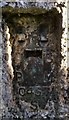
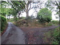
Ordnance Survey Flush Bracket (S0457)
This OS Flush Bracket can be found on the SW face of the Lodge. It marks a point 193.858m above mean sea level.
Image: © Adrian Dust
Taken: 26 Nov 2016
0.01 miles
2
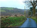
Lon wledig, Harford / Country lane, Harford.
Lon gul rhwng Harford a Esgairdawe / Narrow lane between Harford and Esgairdawe.
Image: © Ian Medcalf
Taken: 20 Dec 2008
0.08 miles
3
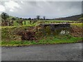
Ordnance Survey Rivet
This damaged OS rivet can be found on the NE parapet of the bridge. It marked a point 189.500m above mean sea level.
Image: © Adrian Dust
Taken: 2 Feb 2023
0.09 miles
4
Heol fynedfa Gwarallt / Gwarallt access road
Heol fynedfa Gwarallt yn gadael y ffordd.
Gwarallt (trans. upper part of the hill) access road exiting the road.
Image: © Alan Richards
Taken: 26 Aug 2022
0.13 miles
5
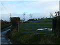
Mynedfa i Cae Amaethyddol / Entrance to Agricultural field.
Llidiart ar bwys croesffordd ger Harford / Gate by a crossroads near Harford.
Image: © Ian Medcalf
Taken: 20 Dec 2008
0.20 miles