IMAGES TAKEN NEAR TO
LLANWRDA, SA19 8BG
Introduction
This page details the photographs taken nearby to SA19 8BG by members of the Geograph project.
The Geograph project started in 2005 with the aim of publishing, organising and preserving representative images for every square kilometre of Great Britain, Ireland and the Isle of Man.

There are currently over 7.5m images from over14,400 individuals and you can help contribute to the project by visiting https://www.geograph.org.uk
Image Map
Images are licensed for reuse under creativecommons.org/licenses/by-sa/2.0
Notes
- Clicking on the map will re-center to the selected point.
- The higher the marker number, the further away the image location is from the centre of the postcode.
Image Listing (6 Images Found)
Images are licensed for reuse under creativecommons.org/licenses/by-sa/2.0
Image
Details
Distance
1
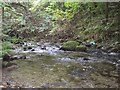
Stream in wooded area alongside road
This shows the Afon Dulais as it runs parallel to the main A482 at this point. This stream is near its source here, so has not gathered a large volume of water yet.
Image: © Roger
Taken: 30 Aug 2008
0.08 miles
2
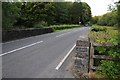
Pont yr Hafod
Pont yr Hafod on the A482.
Image: © Philip Halling
Taken: 19 Sep 2015
0.18 miles
3
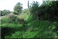
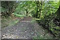
Farm track
Farm track at Hafod Tafolog though not a public right of way.
Image: © Philip Halling
Taken: 19 Sep 2015
0.19 miles
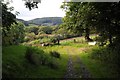
6
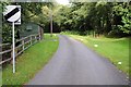
National speed limit
It always appears odd when very narrow country roads such as this one at its junction with the A482 near Pont yr Hafod have a default speed limit of the National Limit.
Image: © Philip Halling
Taken: 19 Sep 2015
0.21 miles