IMAGES TAKEN NEAR TO
Llansawel, LLANDEILO, SA19 7SW
Introduction
This page details the photographs taken nearby to SA19 7SW by members of the Geograph project.
The Geograph project started in 2005 with the aim of publishing, organising and preserving representative images for every square kilometre of Great Britain, Ireland and the Isle of Man.

There are currently over 7.5m images from over14,400 individuals and you can help contribute to the project by visiting https://www.geograph.org.uk
Image Map
Images are licensed for reuse under creativecommons.org/licenses/by-sa/2.0
Notes
- Clicking on the map will re-center to the selected point.
- The higher the marker number, the further away the image location is from the centre of the postcode.
Image Listing (2 Images Found)
Images are licensed for reuse under creativecommons.org/licenses/by-sa/2.0
Image
Details
Distance
1
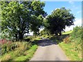
Heol Esgairdawe Road
Heol fach yn mynd i gyfeiriad treflan Esgairdawe.
A minor road heading in the direction of Esgairdawe hamlet (trans. Tawe [stream] ridge).
Image: © Alan Richards
Taken: 18 Aug 2015
0.20 miles
2
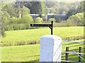
Blaengofiarth
Taken at the 90 degree bend in the road
Image: © John Atherton
Taken: 20 Apr 2007
0.25 miles