IMAGES TAKEN NEAR TO
Penybanc, LLANDEILO, SA19 7SU
Introduction
This page details the photographs taken nearby to SA19 7SU by members of the Geograph project.
The Geograph project started in 2005 with the aim of publishing, organising and preserving representative images for every square kilometre of Great Britain, Ireland and the Isle of Man.

There are currently over 7.5m images from over14,400 individuals and you can help contribute to the project by visiting https://www.geograph.org.uk
Image Map
Images are licensed for reuse under creativecommons.org/licenses/by-sa/2.0
Notes
- Clicking on the map will re-center to the selected point.
- The higher the marker number, the further away the image location is from the centre of the postcode.
Image Listing (13 Images Found)
Images are licensed for reuse under creativecommons.org/licenses/by-sa/2.0
Image
Details
Distance
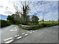
1

Pen-y-banc
A small village about two miles north-west of Llandeilo.
Image: © Graham Horn
Taken: 20 Oct 2008
0.03 miles
2

Chapel at Pen-y-banc
This Siloh Independent chapel was built in 1830 and is still in use.
Image: © Graham Horn
Taken: 20 Oct 2008
0.05 miles
3
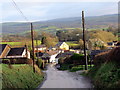
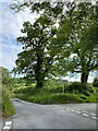
Pen-y-banc
Agosau at bentre Pen-y-banc.
Approaching the village of Pen-y-banc (trans. top of the bank).
Image: © Alan Richards
Taken: 5 Jan 2018
0.08 miles
5
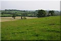
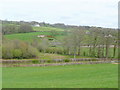
Farmland near Pen-y-Banc
Farmland to the west of the village of Pen-y-Banc.
Image: © Philip Halling
Taken: 18 May 2014
0.14 miles
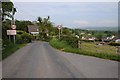
6

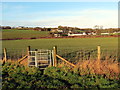
Pen-y-banc cemetery
On a lane towards the A40 about quarter of a mile west of the village.
Image: © Graham Horn
Taken: 20 Oct 2008
0.19 miles
7
View north from the A40
Looking towards Pen-y-banc from the top of the cutting of the trunk road.
Image: © Jonathan Billinger
Taken: 27 Apr 2010
0.19 miles
9
Llwybr Pen-y-banc / Pen-y-banc Path
Llwybr cyhoeddus yn mynd i gyfeiriad pentre Pen-y-banc, yr anheddiad yn y pellter.
A public footpath heading in the direction of Pen-y-banc (trans top of the bank), the settlement in the distance.
Image: © Alan Richards
Taken: 5 Jan 2018
0.21 miles