IMAGES TAKEN NEAR TO
Taliaris, LLANDEILO, SA19 7NH
Introduction
This page details the photographs taken nearby to SA19 7NH by members of the Geograph project.
The Geograph project started in 2005 with the aim of publishing, organising and preserving representative images for every square kilometre of Great Britain, Ireland and the Isle of Man.

There are currently over 7.5m images from over14,400 individuals and you can help contribute to the project by visiting https://www.geograph.org.uk
Image Map
Images are licensed for reuse under creativecommons.org/licenses/by-sa/2.0
Notes
- Clicking on the map will re-center to the selected point.
- The higher the marker number, the further away the image location is from the centre of the postcode.
Image Listing (3 Images Found)
Images are licensed for reuse under creativecommons.org/licenses/by-sa/2.0
Image
Details
Distance
1
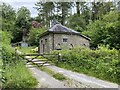
Taliaris Lodge
A Grade II listed building, once the lodge to Plas Taliaris Mansion.
Image: © Alan Hughes
Taken: 22 Jun 2021
0.01 miles
2
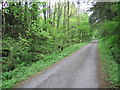
Spring idyll
Lovely spring greenery.
Image: © Neville Goodman
Taken: 16 May 2009
0.06 miles
3
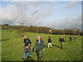
Ger / Near Plas Taliaris Mansion
Cerddwyr yn dilyn llwybr cyhoeddus ar draws cae ger Taliaris.
Walkers following a public footpath across a field near Taliaris (trans. end of place of hens).
Image: © Alan Richards
Taken: 25 Nov 2007
0.22 miles