IMAGES TAKEN NEAR TO
Capel Isaac, LLANDEILO, SA19 7HF
Introduction
This page details the photographs taken nearby to SA19 7HF by members of the Geograph project.
The Geograph project started in 2005 with the aim of publishing, organising and preserving representative images for every square kilometre of Great Britain, Ireland and the Isle of Man.

There are currently over 7.5m images from over14,400 individuals and you can help contribute to the project by visiting https://www.geograph.org.uk
Image Map
Images are licensed for reuse under creativecommons.org/licenses/by-sa/2.0
Notes
- Clicking on the map will re-center to the selected point.
- The higher the marker number, the further away the image location is from the centre of the postcode.
Image Listing (8 Images Found)
Images are licensed for reuse under creativecommons.org/licenses/by-sa/2.0
Image
Details
Distance
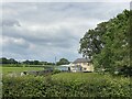
2

Castell-Howel
Sheep and cattle farm on one of the lanes north of Llandeilo.
Image: © Graham Horn
Taken: 20 Oct 2008
0.02 miles
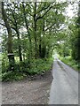
3
Country road near Castell-Howel
Country road near Castell-Howel to the west of Salem.
Image: © Philip Halling
Taken: 18 May 2014
0.11 miles
4
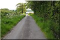
Country road approaching Castell-Howel
Country road approaching Castell-Howel west of Salem.
Image: © Philip Halling
Taken: 18 May 2014
0.12 miles
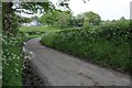
5
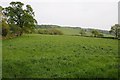
Farmland near Pantybedw
Farmland near Pantybedw to the west of Salem.
Image: © Philip Halling
Taken: 18 May 2014
0.14 miles
6

Pasture at Hafod
Its raining again. I guess that's what makes it so green.
Image: © Graham Horn
Taken: 20 Oct 2008
0.18 miles
7

Feeder at Pantybedw
The farm buildings at Pantybedw are off to the left. The feeder is by the entrance track to the farm, and shows that the pasture is probably used by cattle or horses; too high for sheep which are the main livestock around the area.
Image: © Graham Horn
Taken: 20 Oct 2008
0.19 miles