IMAGES TAKEN NEAR TO
Capel Isaac, LLANDEILO, SA19 7ER
Introduction
This page details the photographs taken nearby to SA19 7ER by members of the Geograph project.
The Geograph project started in 2005 with the aim of publishing, organising and preserving representative images for every square kilometre of Great Britain, Ireland and the Isle of Man.

There are currently over 7.5m images from over14,400 individuals and you can help contribute to the project by visiting https://www.geograph.org.uk
Image Map
Images are licensed for reuse under creativecommons.org/licenses/by-sa/2.0
Notes
- Clicking on the map will re-center to the selected point.
- The higher the marker number, the further away the image location is from the centre of the postcode.
Image Listing (3 Images Found)
Images are licensed for reuse under creativecommons.org/licenses/by-sa/2.0
Image
Details
Distance
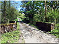
1

Road
Looking up the road from the entrance to the lane for Pistyll-south
Image: © Dara Jasumani
Taken: 21 Apr 2006
0.17 miles
2
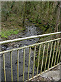
Bridge
Looking north from the bridge at SN 590 288.
Image: © Dara Jasumani
Taken: 21 Apr 2006
0.21 miles
3
Pont ger Llwyn-march / Bridge near Llwyn-march
Pont yn rhychwantu Afon Dulais ger anhedd-dy o'r enw Llwyn-march.
A bridge spanning Afon Dulais (trans. black water) near a property known as Llwyn-march (trans. grove of the stallion).
Image: © Alan Richards
Taken: 17 May 2021
0.22 miles