IMAGES TAKEN NEAR TO
Talley, LLANDEILO, SA19 7DZ
Introduction
This page details the photographs taken nearby to SA19 7DZ by members of the Geograph project.
The Geograph project started in 2005 with the aim of publishing, organising and preserving representative images for every square kilometre of Great Britain, Ireland and the Isle of Man.

There are currently over 7.5m images from over14,400 individuals and you can help contribute to the project by visiting https://www.geograph.org.uk
Image Map
Images are licensed for reuse under creativecommons.org/licenses/by-sa/2.0
Notes
- Clicking on the map will re-center to the selected point.
- The higher the marker number, the further away the image location is from the centre of the postcode.
Image Listing (3 Images Found)
Images are licensed for reuse under creativecommons.org/licenses/by-sa/2.0
Image
Details
Distance
1
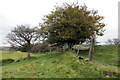
Llwybr ger Gorsyrhwch / Path near Gorsyrhwch
Llwybr cyhoeddus yr ucheldir uwchben Ffarm Gorsyrhwch.
An upland public footpath above Gorsyrhwch Farm (trans. bog of the sow).
Image: © Alan Richards
Taken: 17 Oct 2015
0.13 miles
2
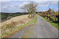
No through road above Talley
This no through road to the east of Talley provides access to farmland. The road follows a ridge at just over 1,000 feet and offers fine views of the surrounding countryside.
Image: © Philip Halling
Taken: 5 May 2013
0.25 miles
3
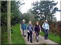
Ger Capel Carmel / Near Carmel Chapel
Cerddwyr yn dilyn heol fach tuag at Gapel Carmel.
Walkers following a minor road towards Carmel Chapel.
Image: © Alan Richards
Taken: 15 Oct 2006
0.25 miles