IMAGES TAKEN NEAR TO
Talley, LLANDEILO, SA19 7DR
Introduction
This page details the photographs taken nearby to SA19 7DR by members of the Geograph project.
The Geograph project started in 2005 with the aim of publishing, organising and preserving representative images for every square kilometre of Great Britain, Ireland and the Isle of Man.

There are currently over 7.5m images from over14,400 individuals and you can help contribute to the project by visiting https://www.geograph.org.uk
Image Map (Loading...)


Getting Data...Please wait
Leaflet Map data © OpenStreetMap
Images are licensed for reuse under creativecommons.org/licenses/by-sa/2.0
Notes
- Clicking on the map will re-center to the selected point.
- The higher the marker number, the further away the image location is from the centre of the postcode.
Image Listing (3 Images Found)
Images are licensed for reuse under creativecommons.org/licenses/by-sa/2.0
Image
Details
Distance
1
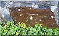
Ordnance Survey Cut Mark
This OS cut mark can be found on the barn at Glan-yr-afon-ddu-ganol. It marks a point 91.172m above mean sea level.
Image: © Adrian Dust
Taken: 7 Jan 2017
0.03 miles
2
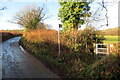
Llwybr yn gadael yr heol / Path exiting the road
Llwybr cyhoeddus yn gadael heol fach ac yn mynd i gyfeiriad Talyllychau.
A public footpath exiting a minor road and heading towards Talley < Talyllychau (trans. end of the lakes).
Image: © Alan Richards
Taken: 6 Dec 2021
0.23 miles
3
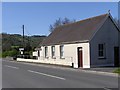
Ebenezer Evangelical Church
Ebenezer Evangelical Church on the B4302 at Halfway.
Image: © John Atherton
Taken: 19 Apr 2007
0.25 miles