IMAGES TAKEN NEAR TO
Talley, LLANDEILO, SA19 7BJ
Introduction
This page details the photographs taken nearby to SA19 7BJ by members of the Geograph project.
The Geograph project started in 2005 with the aim of publishing, organising and preserving representative images for every square kilometre of Great Britain, Ireland and the Isle of Man.

There are currently over 7.5m images from over14,400 individuals and you can help contribute to the project by visiting https://www.geograph.org.uk
Image Map
Images are licensed for reuse under creativecommons.org/licenses/by-sa/2.0
Notes
- Clicking on the map will re-center to the selected point.
- The higher the marker number, the further away the image location is from the centre of the postcode.
Image Listing (4 Images Found)
Images are licensed for reuse under creativecommons.org/licenses/by-sa/2.0
Image
Details
Distance
1
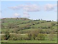
View to Pen-y-gareg
View across the valley to Pen-y-gareg near Talley.
Image: © Philip Halling
Taken: 5 May 2013
0.18 miles
2
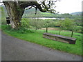
Sit, admire, and eat
A bench and a handy litter bin overlook one of the lakes attached to Talley Abbey: the nearest part of the lake is in the square.
Image: © Neville Goodman
Taken: 18 May 2009
0.21 miles
3
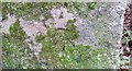
Ordnance Survey Cut Mark
This OS cut mark can be found on the milk stand at Cilyllynfawr Farm. It marks a point 134.623m above mean sea level.
Image: © Adrian Dust
Taken: 7 Jan 2017
0.22 miles