IMAGES TAKEN NEAR TO
Bethlehem, LLANDEILO, SA19 6YB
Introduction
This page details the photographs taken nearby to SA19 6YB by members of the Geograph project.
The Geograph project started in 2005 with the aim of publishing, organising and preserving representative images for every square kilometre of Great Britain, Ireland and the Isle of Man.

There are currently over 7.5m images from over14,400 individuals and you can help contribute to the project by visiting https://www.geograph.org.uk
Image Map
Images are licensed for reuse under creativecommons.org/licenses/by-sa/2.0
Notes
- Clicking on the map will re-center to the selected point.
- The higher the marker number, the further away the image location is from the centre of the postcode.
Image Listing (15 Images Found)
Images are licensed for reuse under creativecommons.org/licenses/by-sa/2.0
Image
Details
Distance
1
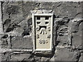
Ordnance Survey Flush Bracket 885
This can be found on the parapet of Pontbren Araeth.
For more detail see : http://www.bench-marks.org.uk/bm10012
Image: © Peter Wood
Taken: 20 Apr 2015
0.04 miles
2
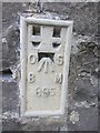
Ordnance Survey Flush Bracket (885)
This OS Flush Bracket (885) can be found on Pontbren Araeth. The road bridge over the Afon Areath. It was used during the Second Geodetic Levelling of England & Wales (1912-21) Carmarthen - Llandovery Levelling Line. Also the Third Geodetic Levelling of England & Wales (1950-68) Llandovery - Carmarthen Levelling Line. It marks a point 141.2380ft above mean sea level.
Image: © Adrian Dust
Taken: 1 Jun 2013
0.04 miles
3
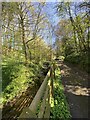
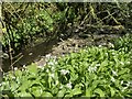
Stream, fence and path
- at Pontbren Araeth, near Bethel Baptist Chapel.
Image: © Alan Hughes
Taken: 20 Apr 2022
0.06 miles
4
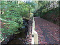
Heol i Gapel Bethel / Road to Bethel Chapel
Heol ar lan Afon Araeth yn arwain at Gapel Bethel.
A road above the Araeth stream heading towards Bethel Chapel.
Image: © Alan Richards
Taken: 19 Oct 2018
0.06 miles
5
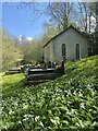
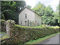
Bethel Chapel
Disused Baptist Chapel in the tranquil valley of Pontbren Araeth.
Image: © Alan Hughes
Taken: 20 Apr 2022
0.12 miles
6
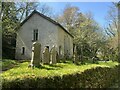
Bethel Baptist Chapel
Built in 1842, now disused.
Image: © Alan Hughes
Taken: 20 Apr 2022
0.12 miles
8
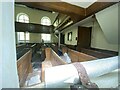
A glimpse of bygone days
Bethel Baptist Chapel was built in 1842 but is now disused and falling into disrepair. This photograph was taken through a chink in a broken window. A scaffolding pole is fastened just inside the window and fallen plaster lies among the pews. The gallery, such a common feature of Welsh chapels of this period, is clearly visible. In such a remote spot were these pews ever full? Perhaps for weddings and funerals in days gone by.
Image: © Alan Hughes
Taken: 20 Apr 2022
0.12 miles
9
Bethel Chapel
On the low wall by the gate is an OS Rivet. http://www.geograph.org.uk/photo/3579341
Image: © Adrian Dust
Taken: 1 Aug 2013
0.13 miles
10
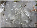
Ordnance Survey Rivet
This OS rivet can be found on a low wall next to the entrance to Bethel Chapel. It marks a point 48.6305m above mean sea level. http://www.geograph.org.uk/photo/3579355
Image: © Adrian Dust
Taken: 1 Aug 2013
0.14 miles