IMAGES TAKEN NEAR TO
LLANDEILO, SA19 6RY
Introduction
This page details the photographs taken nearby to SA19 6RY by members of the Geograph project.
The Geograph project started in 2005 with the aim of publishing, organising and preserving representative images for every square kilometre of Great Britain, Ireland and the Isle of Man.

There are currently over 7.5m images from over14,400 individuals and you can help contribute to the project by visiting https://www.geograph.org.uk
Image Map (Loading...)


Getting Data...Please wait
Leaflet Map data © OpenStreetMap
Images are licensed for reuse under creativecommons.org/licenses/by-sa/2.0
Notes
- Clicking on the map will re-center to the selected point.
- The higher the marker number, the further away the image location is from the centre of the postcode.
Image Listing (5 Images Found)
Images are licensed for reuse under creativecommons.org/licenses/by-sa/2.0
Image
Details
Distance
3
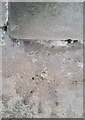
Ordnance Survey Rivet
This OS rivet can be found at the angle of Gate House at the road junction. It marks a point 45.036m above mean sea level.
Image: © Adrian Dust
Taken: 20 Mar 2021
0.09 miles
4
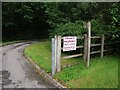
Illegal sign on footpath
Walkers don't seem to be welcome around here.
Image: © Alistair Hare
Taken: 29 Jul 2012
0.12 miles
5
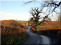
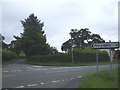
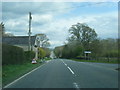
Tuag at yr A40 / Towards the A40
Heol fach yn agosau at groesffordd ar yr A40.
A minor road approaching a crossroads on the A40.
Image: © Alan Richards
Taken: 5 Jan 2018
0.12 miles