IMAGES TAKEN NEAR TO
Carmarthen Road, LLANDEILO, SA19 6RP
Introduction
This page details the photographs taken nearby to Carmarthen Road, SA19 6RP by members of the Geograph project.
The Geograph project started in 2005 with the aim of publishing, organising and preserving representative images for every square kilometre of Great Britain, Ireland and the Isle of Man.

There are currently over 7.5m images from over14,400 individuals and you can help contribute to the project by visiting https://www.geograph.org.uk
Image Map
Images are licensed for reuse under creativecommons.org/licenses/by-sa/2.0
Notes
- Clicking on the map will re-center to the selected point.
- The higher the marker number, the further away the image location is from the centre of the postcode.
Image Listing (94 Images Found)
Images are licensed for reuse under creativecommons.org/licenses/by-sa/2.0
Image
Details
Distance
1
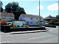
Llandeilo Police Station
Part of Dyfed-Powys Police force, Llandeilo Police Station is at 17-18 Carmarthen Road.
Image: © Jaggery
Taken: 26 Jun 2011
0.01 miles
2
Ambulance Station and an emergency ambulance, Llandeilo
Located on the north side of Carmarthen Road, next door to the fire station. http://www.geograph.org.uk/photo/3271814
Llandeilo Police Station http://www.geograph.org.uk/photo/3271828 is also nearby, on the opposite side of the road.
Image: © Jaggery
Taken: 26 Jun 2011
0.03 miles
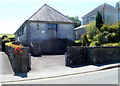
3
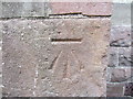
Ordnance Survey Cut Mark
This OS Cut Mark can be found on the NE face of the East Lodge. It marks a point 76.6608m above mean sea level.
Image: © Adrian Dust
Taken: 28 Jul 2013
0.04 miles
4
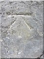
Ordnance Survey Cut Mark
This OS Cut Mark can be found on the corner of the Old Fire Station/Market Hall. This bench mark was used during the First primary levelling, England & Wales (1840-1860), and was levelled with a height of 235.8280 feet [71.8804 metres] above mean sea level (Liverpool datum). It was included on the Llanstephan to Dolfar Toll House levelling line. http://www.geograph.org.uk/photo/3573281
Image: © Adrian Dust
Taken: 28 Jul 2013
0.04 miles
5
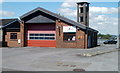
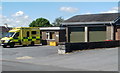
Llandeilo Fire Station
Located on the north side of Carmarthen Road, the fire station is part of the Carmarthenshire Command of Mid and West Wales Fire and Rescue Service.
The fire station is alongside the ambulance station, http://www.geograph.org.uk/photo/3271823 out of shot on the left.
Image: © Jaggery
Taken: 26 Jun 2011
0.04 miles
6
St David's RC church, Llandeilo
The Roman Catholic church occupies a converted former BT telephone exchange on Carmarthen Road. The first Mass in the new church was said on Palm Sunday, April 12th 1987.
Image: © Jaggery
Taken: 26 Jun 2011
0.06 miles
7
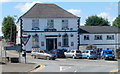
Yr Hen Vic, Llandeilo
Pub and restaurant at 82 New Road, viewed from the corner of Carmarthen Street.
Image: © Jaggery
Taken: 26 Jun 2011
0.08 miles
8
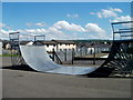
Skateboard ramp, Le Conquet Park, Llandeilo
Part of a recreation area named Le Conquet Park, between Carmarthen Road and Dynevor Avenue.
Image: © Jaggery
Taken: 26 Jun 2011
0.08 miles
9
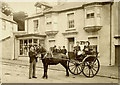
New Road in Llandeilo, Carmarthenshire
Ceffyl a thrap yn Llandeilo!
This is No 80 New Road in Llandeilo, circa 1908. Highly uncertain about the date. The large building on the left edge is now the Yr Hen Vic pub and restaurant, which receives good reviews!
The image is from my family archive. I think I know who the little girl in the trap is. What we need now is a new image. In the meantime:https://www.google.co.uk/maps/@51.8839007,-3.995571,3a,37.5y,288.18h,93.1t/data=!3m6!1e1!3m4!1smvNBVBEBxynyj_X03ZGSww!2e0!7i13312!8i6656
Image: © Unknown
Taken: Unknown
0.09 miles
10
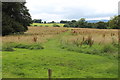
Footpath, Dynefwr Park, to Dynevor Farm
Public field footpath, viewed from the entrance drive to Newton House, although officially the path starts at a gate in the wall to the right, out of picture.
Image: © M J Roscoe
Taken: 29 Jul 2016
0.09 miles