IMAGES TAKEN NEAR TO
Ffairfach, LLANDEILO, SA19 6PB
Introduction
This page details the photographs taken nearby to SA19 6PB by members of the Geograph project.
The Geograph project started in 2005 with the aim of publishing, organising and preserving representative images for every square kilometre of Great Britain, Ireland and the Isle of Man.

There are currently over 7.5m images from over14,400 individuals and you can help contribute to the project by visiting https://www.geograph.org.uk
Image Map (Loading...)


Getting Data...Please wait
Leaflet Map data © OpenStreetMap
Images are licensed for reuse under creativecommons.org/licenses/by-sa/2.0
Notes
- Clicking on the map will re-center to the selected point.
- The higher the marker number, the further away the image location is from the centre of the postcode.
Image Listing (2 Images Found)
Images are licensed for reuse under creativecommons.org/licenses/by-sa/2.0
Image
Details
Distance
1
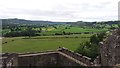
Vale of Tywi from Castell Dinefwr (Dynevor Castle)
Looking down the vale of Tywi from the ruins of Dynevor Castle. With the eye of faith Paxton's Tower can just be made out on the horizon. Closer to, the Afon Tywi winds through the fields, beyond which the track bed of the former Llandeilo to Carmarthen railway (closed in 1963) is clearly visible, heading towards Gelli Aur (Golden Grove).
Image: © Nigel Wassell
Taken: 27 Aug 2018
0.14 miles
2
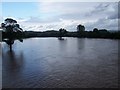
Tywi Valley Flood Plain upstream from Cilsan Bridge
A period of rain over a couple of weeks culminating in very heavy rain over 16/17 July 2009 resulted in high river levels in the afternoon of 17 July.
Image: © George Causley
Taken: 17 Jul 2009
0.22 miles