IMAGES TAKEN NEAR TO
Blende Road, LLANDEILO, SA19 6NE
Introduction
This page details the photographs taken nearby to Blende Road, SA19 6NE by members of the Geograph project.
The Geograph project started in 2005 with the aim of publishing, organising and preserving representative images for every square kilometre of Great Britain, Ireland and the Isle of Man.

There are currently over 7.5m images from over14,400 individuals and you can help contribute to the project by visiting https://www.geograph.org.uk
Image Map
Images are licensed for reuse under creativecommons.org/licenses/by-sa/2.0
Notes
- Clicking on the map will re-center to the selected point.
- The higher the marker number, the further away the image location is from the centre of the postcode.
Image Listing (71 Images Found)
Images are licensed for reuse under creativecommons.org/licenses/by-sa/2.0
Image
Details
Distance
1
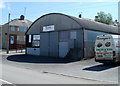
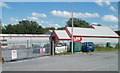
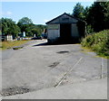
MotoVeCo, Llandeilo
MotoVeCo occupies a large corrugated metal building on the corner of Station Road and Blende Road.
The business sells camper vans and other vans. It also supplies, installs and checks gas appliances and installations on campers, motorhomes and tourers. Aftermarket seats and windows are also available to order. A selection of electrical, plumbing and other accessories are stocked.
Image: © Jaggery
Taken: 26 Jun 2011
0.03 miles
2
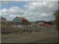
Llandeilo Yard
Builder's yard in Llandeilo.
Image: © Gerald England
Taken: 29 Apr 2006
0.03 miles
3
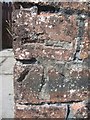
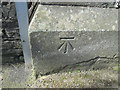
Ordnance Survey Cut Mark
This OS Cut Mark can be found on a brick wall to the west of Thomas Street. It marks a point 45.1690m above mean sea level.
Image: © Adrian Dust
Taken: 28 Jul 2013
0.03 miles
4
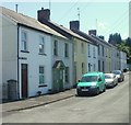
Thomas Terrace, Llandeilo
Viewed from the Station Road end. Thomas Terrace is a row of 11 houses.
The opposite side is occupied by a warehouse.
Image: © Jaggery
Taken: 26 Jun 2011
0.04 miles
5
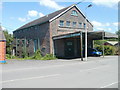
LBS head office, Llandeilo
Located near Llandeilo railway station, this is the Station Road head office of LBS Builders Merchants. The business has several branches in SW Wales, include one nearby in Rhosmaen Street. http://www.geograph.org.uk/photo/3271938
Image: © Jaggery
Taken: 26 Jun 2011
0.05 miles
6
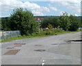
Station approach, Llandeilo
A view along Station Road. In contrast to the central location of Llandovery's railway station http://www.geograph.org.uk/photo/2646660, Llandeilo's railway station is tucked away at the eastern edge of town, about a kilometre by road from the central shopping area of Llandeilo.
Image: © Jaggery
Taken: 26 Jun 2011
0.08 miles
7
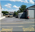
Coach depot, Llandeilo
Located on the east side of Rhosmaen Street (the A483),
this is the Llandeilo coach depot of Thomas Brothers of Llangadog.
Image: © Jaggery
Taken: 26 Jun 2011
0.08 miles
8
James Ash Antiques, Llandeilo
Located in The Warehouse, Station Road, adjacent to The Works Antiques Centre. http://www.geograph.org.uk/photo/3273722
The business sells Welsh, English and European antique and later furniture & accessories,
in oak, mahogany, walnut & other timbers. Welsh longcase clocks are a speciality.
Image: © Jaggery
Taken: 26 Jun 2011
0.08 miles
9
Railway track remnant, Station Road, Llandeilo
A disconnected couple of metres of railway track remains on Station Road, near Dinefwr Joinery. http://www.geograph.org.uk/photo/3273895
Llandeilo railway station is on the left.
Image: © Jaggery
Taken: 26 Jun 2011
0.08 miles
10
Ordnance Survey Cut Mark
This OS cut mark can be found on the SE angle of the school building. It marks a point 43.209m above mean sea level.
Image: © Adrian Dust
Taken: 22 Mar 2015
0.08 miles