IMAGES TAKEN NEAR TO
LLANDEILO, SA19 6BQ
Introduction
This page details the photographs taken nearby to SA19 6BQ by members of the Geograph project.
The Geograph project started in 2005 with the aim of publishing, organising and preserving representative images for every square kilometre of Great Britain, Ireland and the Isle of Man.

There are currently over 7.5m images from over14,400 individuals and you can help contribute to the project by visiting https://www.geograph.org.uk
Image Map
Images are licensed for reuse under creativecommons.org/licenses/by-sa/2.0
Notes
- Clicking on the map will re-center to the selected point.
- The higher the marker number, the further away the image location is from the centre of the postcode.
Image Listing (194 Images Found)
Images are licensed for reuse under creativecommons.org/licenses/by-sa/2.0
Image
Details
Distance
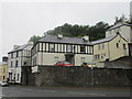
2
Bridge Street, Llandeilo from St Teilo's Church
Image: © Jeff Gogarty
Taken: 17 Sep 2022
0.02 miles
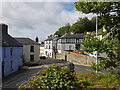
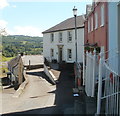
3
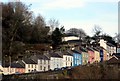
Colourful houses above Llandeilo bridge
This row of houses on the steep hill leading from the river to the town provide a colourful welcome to visitors to Llandeilo
Image: © Flying Stag
Taken: 6 Jan 2011
0.02 miles
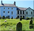
4
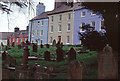
Bank Terrace and St Teilo's churchyard, Llandeilo
Llandeilo is an attractive and ancient town with ecclesiastical roots going back at least to the 9th century. The parish church is dedicated to St Teilo, an obscure figure believed to have been buried here. There is a large churchyard of which a small part is shown here with a backdrop of houses on Bank Terrace.
Image: © Stephen McKay
Taken: Unknown
0.03 miles
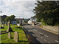
5
Church Street meets Bridge Street, Llandeilo
Image: © Jeff Gogarty
Taken: 17 Sep 2022
0.03 miles
6
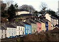
Colourful houses above Llandeilo bridge
(Enlargement of preceding photo).This row of houses on the steep hill leading from the river to the town provide a colourful welcome to visitors to Llandeilo
Image: © Flying Stag
Taken: 6 Jan 2011
0.03 miles
7
The Old Bank, Llandeilo
This view from a churchyard shows part of Bank Terrace. There is a blue plaque http://www.geograph.org.uk/photo/3270636 on the building on the right, now the office of IRP Wealth Planning. The plaque records that the building was formerly a branch of the Bank of the Black Ox, symbolic of the drovers, established in 1842. The bank issued its own Llandeilo style banknotes.
Image: © Jaggery
Taken: 26 Jun 2011
0.04 miles
8
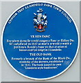
The Old Bank blue plaque, Llandeilo
The plaque is fixed to the wall here. http://www.geograph.org.uk/photo/3270635
Image: © Jaggery
Taken: 26 Jun 2011
0.04 miles
9
SW end of Bank Terrace, Llandeilo
Bank Terrace is a short cul-de-sac on the SW side of the street named George Hill.
Image: © Jaggery
Taken: 26 Jun 2011
0.04 miles
10
St Teilo's church, Llandeilo
Grade II listed Church in Wales church viewed along Church Street from the corner of Bridge Street.
The tower is late medieval, but the rest of the church is a rebuild, completed in 1850. The churchyard and church site date back many centuries. Llandeilo's history as a Christian centre can be traced back to the sixth century.
Very little is known for certain about St Teilo (born c500, died c560). There are many churches dedicated to him in South Wales, and also in Brittany.
Image: © Jaggery
Taken: 26 Jun 2011
0.04 miles