IMAGES TAKEN NEAR TO
Ysgol Street, SWANSEA, SA1 8LF
Introduction
This page details the photographs taken nearby to Ysgol Street, SA1 8LF by members of the Geograph project.
The Geograph project started in 2005 with the aim of publishing, organising and preserving representative images for every square kilometre of Great Britain, Ireland and the Isle of Man.

There are currently over 7.5m images from over14,400 individuals and you can help contribute to the project by visiting https://www.geograph.org.uk
Image Map (Loading...)


Getting Data...Please wait
Leaflet Map data © OpenStreetMap
Images are licensed for reuse under creativecommons.org/licenses/by-sa/2.0
Notes
- Clicking on the map will re-center to the selected point.
- The higher the marker number, the further away the image location is from the centre of the postcode.
Image Listing (58 Images Found)
Images are licensed for reuse under creativecommons.org/licenses/by-sa/2.0
Image
Details
Distance
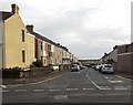
1
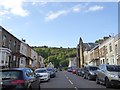
Ysgol Street, Dan-y-Graig
Looking up the street to the church
Image: © David Smith
Taken: 2 Jun 2018
0.05 miles
2
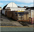
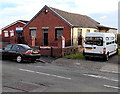
Ysgol Street hall to let, Swansea
The hall is between Ysgol Street on this side and Pant Street ahead. A nearby resident told me that the hall was recently in use as a children's nursery. An earlier use was as Calvary Chapel.
Image: © Jaggery
Taken: 10 Nov 2013
0.05 miles
3
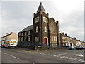
Ty Beddoe flats, Swansea
On the corner of Danygraig Road and Ysgol Street.
Formerly Mount Calvary Baptist Church, converted to flats c2000.
Image: © Jaggery
Taken: 10 Nov 2013
0.05 miles
4
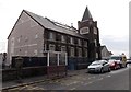
Eastern side of Ty Beddoe flats, Swansea
Viewed across Danygraig Road. Formerly Mount Calvary Baptist Church, converted to flats c2000.
Image: © Jaggery
Taken: 10 Nov 2013
0.05 miles
5
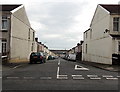
Jersey Terrace, Swansea
Looking coastwards (south) across Danygraig Road.
Image: © Jaggery
Taken: 10 Nov 2013
0.05 miles
6
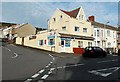
Port Tennant Kebab & Pizza shop, Swansea
On the corner of Ysgol Street and Wern Fawr Road.
Image: © Jaggery
Taken: 10 Nov 2013
0.06 miles
7
Jersey Terrace, Swansea
Viewed from Ysgol Street. Danygraig Primary School is on the left.
Image: © Jaggery
Taken: 10 Nov 2013
0.07 miles
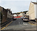
8
Pant Street, Swansea
Viewed from Wern Fawr Road looking north towards Danygraig Road about 200 metres ahead.
Image: © Jaggery
Taken: 10 Nov 2013
0.08 miles
9
Ebenezer Gospel Hall, Swansea
Located in Wern Fawr Road. On the left is Port Tennant Community Centre.
Image: © Jaggery
Taken: 10 Nov 2013
0.08 miles
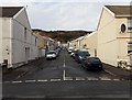
10
Pant Street Swansea
Looking south across Danygraig Road along Pant Street towards Wern Fawr Road.
Image: © Jaggery
Taken: 10 Nov 2013
0.09 miles