IMAGES TAKEN NEAR TO
Upton Terrace, SWANSEA, SA1 8HL
Introduction
This page details the photographs taken nearby to Upton Terrace, SA1 8HL by members of the Geograph project.
The Geograph project started in 2005 with the aim of publishing, organising and preserving representative images for every square kilometre of Great Britain, Ireland and the Isle of Man.

There are currently over 7.5m images from over14,400 individuals and you can help contribute to the project by visiting https://www.geograph.org.uk
Image Map (Loading...)


Getting Data...Please wait
Leaflet Map data © OpenStreetMap
Images are licensed for reuse under creativecommons.org/licenses/by-sa/2.0
Notes
- Clicking on the map will re-center to the selected point.
- The higher the marker number, the further away the image location is from the centre of the postcode.
Image Listing (51 Images Found)
Images are licensed for reuse under creativecommons.org/licenses/by-sa/2.0
Image
Details
Distance
1
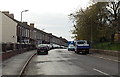
Osterley Street, Swansea
Viewed across Port Tennant Road looking towards Upton Terrace. An eyesore http://www.geograph.org.uk/photo/3744875 is on the right.
Image: © Jaggery
Taken: 10 Nov 2013
0.01 miles
2
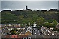
Danygraig, Swansea
View from the Village Hotel to Kilvey Hill
Image: © Deborah Tilley
Taken: 5 Jun 2015
0.04 miles
3
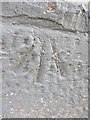
Ordnance Survey Cut Mark
This OS cut mark can be found on the front of No19 Middleton Road. It marks a point 29.212m above mean sea level.
Image: © Adrian Dust
Taken: 24 Oct 2013
0.04 miles
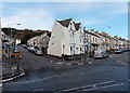
4
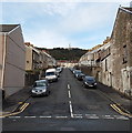
Middleton Street, Swansea
Viewed across Port Tennant Road looking towards Kinley Street.
Image: © Jaggery
Taken: 10 Nov 2013
0.05 miles
5
Longford Crescent, Swansea
Viewed from the St Illtyd's Crescent end looking towards
a 110-metre long row of houses opposite Jersey Park.
Image: © Jaggery
Taken: 10 Nov 2013
0.06 miles
6
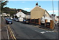
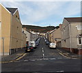
Kinley Street, Swansea
Kinley Street climbs away from Port Tennant Road in the St Thomas area of Swansea.
Image: © Jaggery
Taken: 10 Nov 2013
0.08 miles
7
Junction of Margaret Street and Danygraig Road, Swansea
Viewed across Port Tennant Road. Margaret Street is on the left.
Image: © Jaggery
Taken: 10 Nov 2013
0.10 miles
8
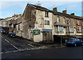
Eyesore on the corner of Osterley Street and Port Tennant Road, Swansea
The Dental Practice and Cosmetic Dentistry signs look newish, but the rest of this corner is very shabby. Vegetation is growing in the guttering. A faded name on the building suggests that this was a solicitors' office before it was used for dentistry. Three years before this view was taken in November 2013, a local paper had reported that an application to convert this corner to six residential units had been submitted to Swansea Council's planning committee...
Image: © Jaggery
Taken: 10 Nov 2013
0.10 miles
9
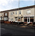
The Barber, Port Tennant Road, Swansea
The anonymous barber shop is between Middleton Street and Osterley Street.
Image: © Jaggery
Taken: 10 Nov 2013
0.10 miles
10
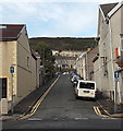
Lee Street, Swansea
Lee Street climbs away from Port Tennant Road towards Kinley Street.
A one-way system applies along Lee Street, direction away from the camera
Image: © Jaggery
Taken: 10 Nov 2013
0.11 miles