IMAGES TAKEN NEAR TO
St. Leger Crescent, SWANSEA, SA1 8EU
Introduction
This page details the photographs taken nearby to St. Leger Crescent, SA1 8EU by members of the Geograph project.
The Geograph project started in 2005 with the aim of publishing, organising and preserving representative images for every square kilometre of Great Britain, Ireland and the Isle of Man.

There are currently over 7.5m images from over14,400 individuals and you can help contribute to the project by visiting https://www.geograph.org.uk
Image Map (Loading...)


Getting Data...Please wait
Leaflet Map data © OpenStreetMap
Images are licensed for reuse under creativecommons.org/licenses/by-sa/2.0
Notes
- Clicking on the map will re-center to the selected point.
- The higher the marker number, the further away the image location is from the centre of the postcode.
Image Listing (62 Images Found)
Images are licensed for reuse under creativecommons.org/licenses/by-sa/2.0
Image
Details
Distance
1
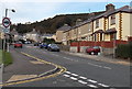
St Leger Crescent, Swansea
Viewed from the eastern end of Delhi Street in the St Thomas area of Swansea.
Image: © Jaggery
Taken: 10 Nov 2013
0.02 miles
2

View From Kilvey Hill
Looking down over St Thomas'.
Image: © Deborah Tilley
Taken: 18 Jun 2016
0.03 miles
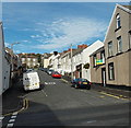
3
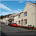
Sebastopol Street houses, Swansea
Houses on the east side of the street, viewed from Delhi Street looking towards Mackworth Terrace.
Image: © Jaggery
Taken: 10 Nov 2013
0.04 miles
4
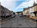
Lewis Street, Swansea
Viewed from the wall at the southern (Fabian Way) end of the street looking north towards Delhi Street.
Image: © Jaggery
Taken: 10 Nov 2013
0.05 miles
5

Ordnance Survey Cut Mark
This OS cut mark can be found on the roadside wall below No65 Grenfell Park Road. It marks a point 42.291m above mean sea level.
Image: © Adrian Dust
Taken: 24 Oct 2013
0.07 miles
6
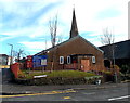
St Thomas's church hall, Swansea
On the corner of Lewis Street and Delhi Street. The church spire http://www.geograph.org.uk/photo/3741613 is in the background.
Image: © Jaggery
Taken: 10 Nov 2013
0.07 miles
7
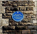
Sir Harry Secombe C.B.E blue plaque on the Parish Church of St Thomas, Swansea
The Heritage Foundation's blue plaque is here. http://www.geograph.org.uk/photo/3741613 It records that Sir Harry Secombe C.B.E (1921-2001), Goon, Comedian and Singer, served here as a boy chorister.
Image: © Jaggery
Taken: 10 Nov 2013
0.08 miles
8
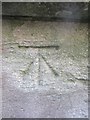
Ordnance Survey Cut Mark
This OS cut mark can be found on the tower of the church of St Thomas. It marks a point 21.467m above mean sea level.
Image: © Adrian Dust
Taken: 24 Oct 2013
0.08 miles
9

Parish Church of St Thomas, Swansea
Viewed across Lewis Street. There used to be a medieval chapel (exact location now lost) dedicated to St Thomas at the foot of Kilvey Hill which gave its name to the hamlet that grew up on the east side of the River Tawe. The church seen here was built in 1886, replacing a mission room.
The blue plaque on the wall commemorates one of the church's boy choristers who later became famous. http://www.geograph.org.uk/photo/3741621
Image: © Jaggery
Taken: 10 Nov 2013
0.09 miles
10
Balaclava Street, Swansea
Viewed across Delhi Street looking north towards Mackworth Terrace.
Image: © Jaggery
Taken: 10 Nov 2013
0.09 miles