IMAGES TAKEN NEAR TO
Blaenau Road, AMMANFORD, SA18 3YR
Introduction
This page details the photographs taken nearby to Blaenau Road, SA18 3YR by members of the Geograph project.
The Geograph project started in 2005 with the aim of publishing, organising and preserving representative images for every square kilometre of Great Britain, Ireland and the Isle of Man.

There are currently over 7.5m images from over14,400 individuals and you can help contribute to the project by visiting https://www.geograph.org.uk
Image Map
Images are licensed for reuse under creativecommons.org/licenses/by-sa/2.0
Notes
- Clicking on the map will re-center to the selected point.
- The higher the marker number, the further away the image location is from the centre of the postcode.
Image Listing (103 Images Found)
Images are licensed for reuse under creativecommons.org/licenses/by-sa/2.0
Image
Details
Distance
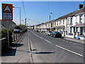
1
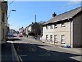
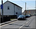
Blaenau Road, Llandybie
The B4556 Blaenau Road heads away from the centre of the village.
Image: © Jaggery
Taken: 23 Apr 2015
0.02 miles
2
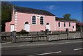
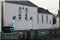
Former Gosen Chapel, Llandybie
Now in residential use, viewed across Blaenau Road in April 2015. This tablet http://www.geograph.org.uk/photo/421245 remains on the building.
Image: © Jaggery
Taken: 23 Apr 2015
0.02 miles
3
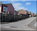
Parc Pencae, Llandybie
21st century housing west of Blaenau Road.
Image: © Jaggery
Taken: 23 Apr 2015
0.02 miles
4
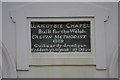
Gosen Chapel,Llandybie
Engraved sign on the wall of Gosen Chapel in Blaenau Road, Llandybie.
Image: © John B R Davies
Taken: 26 Mar 2007
0.04 miles
5
Gosen Chapel, Llandybie
Gosen Chapel in Blaenau Road, Llandybie
Image: © John B R Davies
Taken: 26 Mar 2007
0.04 miles
6
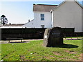
Llandybie Millennium Stone
Located on a grass triangle in the centre of the village. The main side in view shows Llandybie 2000.
The inscription on the metal plate on the side shows that the Millennium Stone was designed and executed by Ieuan Rees. It was unveiled by county councillor Mary H Thomas JP on Saturday January 29th 2000.
Image: © Jaggery
Taken: 23 Apr 2015
0.06 miles
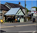
7
Former shop in Llandybie
At the NE end of Blaenau Road, near the A483 and High Street junctions. Dricksie http://www.geograph.org.uk/photo/4444268 is nearby.
Image: © Jaggery
Taken: 23 Apr 2015
0.07 miles
8
Woodfield Road traffic calmed area in Llandybie
The bilingual blue sign is on a pole near the Ammanford Road junction.
Image: © Jaggery
Taken: 23 Apr 2015
0.07 miles
9
Woodfield Road, Llandybie
Looking SW from near the Ammanford Road junction. A bilingual sign shows Humps for 100 yards.
Image: © Jaggery
Taken: 23 Apr 2015
0.07 miles
10
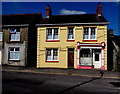
Dricksie, Llandybie
Shop selling household items & gifts at 2 High Street.
Image: © Jaggery
Taken: 23 Apr 2015
0.08 miles