IMAGES TAKEN NEAR TO
Ammanford Road, AMMANFORD, SA18 3YF
Introduction
This page details the photographs taken nearby to Ammanford Road, SA18 3YF by members of the Geograph project.
The Geograph project started in 2005 with the aim of publishing, organising and preserving representative images for every square kilometre of Great Britain, Ireland and the Isle of Man.

There are currently over 7.5m images from over14,400 individuals and you can help contribute to the project by visiting https://www.geograph.org.uk
Image Map
Images are licensed for reuse under creativecommons.org/licenses/by-sa/2.0
Notes
- Clicking on the map will re-center to the selected point.
- The higher the marker number, the further away the image location is from the centre of the postcode.
Image Listing (87 Images Found)
Images are licensed for reuse under creativecommons.org/licenses/by-sa/2.0
Image
Details
Distance
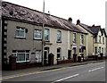
1
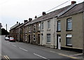
Ammanford Road houses SE of Rawlings Road, Llandybie
Viewed across the A483, here named Ammanford Road.
Image: © Jaggery
Taken: 1 May 2015
0.02 miles
2
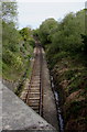
Heart of Wales Line north to Llandybie station
Viewed from the A483 Ammanford Road. Llandybie railway station http://www.geograph.org.uk/photo/4444866 is 550 metres ahead.
Image: © Jaggery
Taken: 1 May 2015
0.05 miles
3
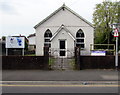
Entrance to Ebenezer Apostolic Community Church, Llandybie
From Ammanford Road. http://www.geograph.org.uk/photo/4455183 to a side view.
Image: © Jaggery
Taken: 1 May 2015
0.06 miles
4
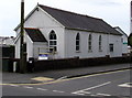
Ebenezer Apostolic Community Church, Llandybie
On the corner of Rawlings Road (on the right) and Ammanford Road.
Image: © Jaggery
Taken: 1 May 2015
0.06 miles
5
Ammanford Road houses, Llandybie
Viewed from the edge of the road bridge over a river, Afon Marlas.
Image: © Jaggery
Taken: 1 May 2015
0.06 miles
6
Rawlings Road, Llandybie
Viewed across Ammanford Road. Ebenezer Apostolic Community Church http://www.geograph.org.uk/photo/4455183 is on the left.
Image: © Jaggery
Taken: 1 May 2015
0.07 miles
7
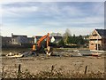
New housing
Construction work in progress on the outskirts of Llandybie.
Image: © Alan Hughes
Taken: 24 Feb 2019
0.07 miles
8
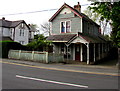
Kimberley Villa, Llandybie
Located on the south bank of a river, Afon Marlas, viewed across Ammanford Road. One online source states that a Llandybie resident emigrated to Cleveland, Ohio, in the 1880s and, after 18 years there as a builder, returned to Llandybie. The only houses he knew how to build were American, which explains this intruder.
The house on the left is in the same style.
Image: © Jaggery
Taken: 1 May 2015
0.07 miles
9
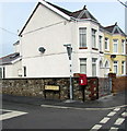
Queen Elizabeth II postbox on a Llandybie corner
On the corner of Margaret Road and the A483 Ammanford Road in Llandybie.
Image: © Jaggery
Taken: 1 May 2015
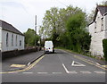
0.08 miles
10
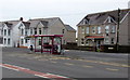
Ammanford Road bus shelter opposite Margaret Road, Llandybie
The house on the right is on the corner of Margaret Road. http://www.geograph.org.uk/photo/4455298
Image: © Jaggery
Taken: 1 May 2015
0.08 miles