IMAGES TAKEN NEAR TO
Ammanford Road, AMMANFORD, SA18 3UW
Introduction
This page details the photographs taken nearby to Ammanford Road, SA18 3UW by members of the Geograph project.
The Geograph project started in 2005 with the aim of publishing, organising and preserving representative images for every square kilometre of Great Britain, Ireland and the Isle of Man.

There are currently over 7.5m images from over14,400 individuals and you can help contribute to the project by visiting https://www.geograph.org.uk
Image Map (Loading...)


Getting Data...Please wait
Leaflet Map data © OpenStreetMap
Images are licensed for reuse under creativecommons.org/licenses/by-sa/2.0
Notes
- Clicking on the map will re-center to the selected point.
- The higher the marker number, the further away the image location is from the centre of the postcode.
Image Listing (112 Images Found)
Images are licensed for reuse under creativecommons.org/licenses/by-sa/2.0
Image
Details
Distance
1
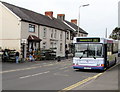
Ammanford bus in Llandybie
On route 103 to Ammanford, the First single-decker is at an Ammanford Road bus stop opposite Hardware House which sells tools, pet foods, kitchen ware, gardening and cleaning products. Two potential customers are looking at the outdoor display of plants.
Image: © Jaggery
Taken: 1 May 2015
0.01 miles
2
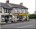
Park Cafe, Llandybie
At 23 Ammanford Road, next door to a Premier Express store on the corner of Woodfield Road.
Image: © Jaggery
Taken: 1 May 2015
0.02 miles
3
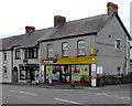
Llandybie Stores, Llandybie
Premier Express convenience store on the corner of Ammanford Road and Woodfield Road.
Park Cafe is next door.
Image: © Jaggery
Taken: 1 May 2015
0.02 miles
4
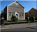
Former Sion chapel, Ammanford Road, Llandybie
In April 2015, the building appears to have been converted to residential use.
There is no nameboard to be seen, only the inscription on the large tablet high up on the wall,
showing SION CAPEL ANNIBYNOL 1896 (Welsh for Zion Independent Chapel).
Image: © Jaggery
Taken: 23 Apr 2015
0.02 miles
5
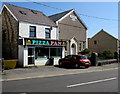
Pizza Pan, Llandybie
The Ammanford Road takeaway is next door to Sion. http://www.geograph.org.uk/photo/4444629
Image: © Jaggery
Taken: 23 Apr 2015
0.03 miles
6
Campbell Road, Llandybie
Looking south from Kings Road. Llandybie Social Club http://www.geograph.org.uk/photo/4442761 is on the left.
Image: © Jaggery
Taken: 23 Apr 2015
0.03 miles
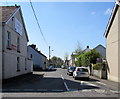
7
Woodfield Road traffic calmed area in Llandybie
The bilingual blue sign is on a pole near the Ammanford Road junction.
Image: © Jaggery
Taken: 23 Apr 2015
0.04 miles
8
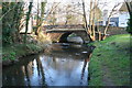
The road bridge over the River Marlais
The roadbridge over the river Marlais leading to King's Road in Llandybie.
Image: © John B R Davies
Taken: 26 Mar 2007
0.04 miles
9
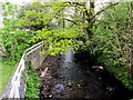
Afon Marlas flows away from Ammanford Road, Llandybie
The river is a tributary of the River Loughor.
Image: © Jaggery
Taken: 1 May 2015
0.05 miles
10
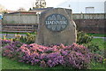
Llandybie Millennium Stone
This stone from the local quarry was erected on Llandybie square in 2000.The calligraphy is by the world famous Ieuan Rees who lives locally.
Image: © John B R Davies
Taken: 26 Mar 2007
0.06 miles