IMAGES TAKEN NEAR TO
Dyffryn Road, AMMANFORD, SA18 3TN
Introduction
This page details the photographs taken nearby to Dyffryn Road, SA18 3TN by members of the Geograph project.
The Geograph project started in 2005 with the aim of publishing, organising and preserving representative images for every square kilometre of Great Britain, Ireland and the Isle of Man.

There are currently over 7.5m images from over14,400 individuals and you can help contribute to the project by visiting https://www.geograph.org.uk
Image Map
Images are licensed for reuse under creativecommons.org/licenses/by-sa/2.0
Notes
- Clicking on the map will re-center to the selected point.
- The higher the marker number, the further away the image location is from the centre of the postcode.
Image Listing (4 Images Found)
Images are licensed for reuse under creativecommons.org/licenses/by-sa/2.0
Image
Details
Distance
1
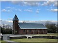
St David?s Church, Saron
Church in Wales church in the village of Saron.
Image: © Alan Hughes
Taken: 10 Feb 2021
0.08 miles
2
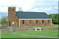
St David's Parish Church, Saron
A modern, brick church - but with some attempt at a traditional design.
Image: © Nigel Davies
Taken: 22 Oct 2005
0.11 miles
3
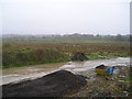
Land reclamation?
View towards Ammanford with mud, rushes and sheep. The ground on which I am standing is raised about 5 metres above surrounding land by the deposit and levelling of rubble and soil from elsewhere.
Image: © Marion Phillips
Taken: 4 Nov 2010
0.21 miles
4
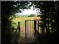
Llwybr Saron Footpath
Gât fochyn ar lwybr cyhoeddus yn Saron.
A kissing gate on a public footpath in Saron.
Image: © Alan Richards
Taken: 26 Jul 2014
0.22 miles