IMAGES TAKEN NEAR TO
Parklands Court, AMMANFORD, SA18 3TJ
Introduction
This page details the photographs taken nearby to Parklands Court, SA18 3TJ by members of the Geograph project.
The Geograph project started in 2005 with the aim of publishing, organising and preserving representative images for every square kilometre of Great Britain, Ireland and the Isle of Man.

There are currently over 7.5m images from over14,400 individuals and you can help contribute to the project by visiting https://www.geograph.org.uk
Image Map (Loading...)


Getting Data...Please wait
Leaflet Map data © OpenStreetMap
Images are licensed for reuse under creativecommons.org/licenses/by-sa/2.0
Notes
- Clicking on the map will re-center to the selected point.
- The higher the marker number, the further away the image location is from the centre of the postcode.
Image Listing (10 Images Found)
Images are licensed for reuse under creativecommons.org/licenses/by-sa/2.0
Image
Details
Distance
2
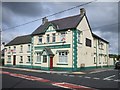
The Golden Lion Hotel, Penybanc Road
Yet another pub that has succumbed to the superstore's squeeze on booze prices.
Image: © Jeremy Bolwell
Taken: 4 Jun 2012
0.04 miles
3
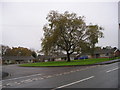
Bryn Euraidd
Crescent of bungalows with an attractive willow tree on the green.
Image: © Marion Phillips
Taken: 4 Nov 2010
0.05 miles
4
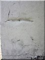
Ordnance Survey Cut Mark
This heavily painted over OS Cut Mark can be found on the front of No62 Penybanc Road. It marks a point 52.1086m above mean sea level.
Image: © Adrian Dust
Taken: 21 Jul 2013
0.07 miles
5
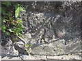
Ordnance Survey Cut Mark
This OS Cut Mark can be found on the east parapet of the bridge in Penybanc. It marks a point 46.2869m above mean sea level.
Image: © Adrian Dust
Taken: 21 Jul 2013
0.08 miles
6
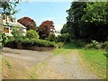
Llwybr Penybanc Path
Llwybr Cyhoeddus ger Parc Wern ym Mhenybanc.
Public footpath near Parc Wern, Penybanc.
Image: © Alan Richards
Taken: 26 Jul 2014
0.10 miles
7
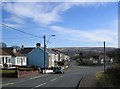
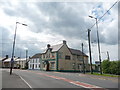
Road junction
On the skyline you can see a distant mast Image to the left, and a row of pylons crossing the ridge to the right.
Image: © Marion Phillips
Taken: 4 Mar 2010
0.11 miles
8
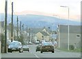
Penybanc near Ammanford
This is the view northeast along the A483 in Penybanc, heading towards Ammanford. The Black Mountain - specifically Tair Carn Isaf - can be seen in the background
Image: © Nigel Davies
Taken: 28 Oct 2005
0.14 miles
9
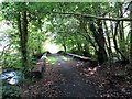
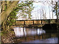
Hen bont Lofa'r Parc / Parc Colliery old bridge
Hen bont reilffordd yn rhychwantu Afon Llwchwr. Cludai'r rheilfordd lo o Lofa'r Parc i'r prif lein yn Rhydaman.
Old railway bridge spanning the Llwchwr (Loughor) River. The railway carried coal from nearby Parc Colliery to the main line in Ammanford.
Image: © Alan Richards
Taken: 26 Jul 2014
0.21 miles