IMAGES TAKEN NEAR TO
Dyffryn Road, AMMANFORD, SA18 3TA
Introduction
This page details the photographs taken nearby to Dyffryn Road, SA18 3TA by members of the Geograph project.
The Geograph project started in 2005 with the aim of publishing, organising and preserving representative images for every square kilometre of Great Britain, Ireland and the Isle of Man.

There are currently over 7.5m images from over14,400 individuals and you can help contribute to the project by visiting https://www.geograph.org.uk
Image Map
Images are licensed for reuse under creativecommons.org/licenses/by-sa/2.0
Notes
- Clicking on the map will re-center to the selected point.
- The higher the marker number, the further away the image location is from the centre of the postcode.
Image Listing (57 Images Found)
Images are licensed for reuse under creativecommons.org/licenses/by-sa/2.0
Image
Details
Distance
1
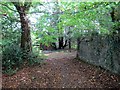
Llwybr Glyntai Fawr Path
Llwybr cyhoeddus yn mynd o gyfeiriad Ffarm Glyntai Fawr tuag at Heol Dyffryn.
A public footpath heading towards Dyffryn Road from the direction of Glyntai Fawr Farm.
Image: © Alan Richards
Taken: 13 Sep 2014
0.02 miles
2
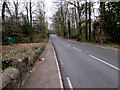
West along Dyffryn Road, Ammanford
Viewed from the bridge carrying the road over a stream, Nant y Ci. http://www.geograph.org.uk/photo/4398676
Image: © Jaggery
Taken: 11 Feb 2015
0.07 miles
3
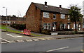
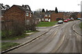
Station Road houses, Ammanford
HEOL-YR-ORSAF is more prominent than STATION ROAD in the bilingual street name sign.
After a few hours in Pontarddulais in the City and County of Swansea earlier in the day, I noticed the greater prominence given to the Welsh language in Ammanford in Carmarthenshire. In the 2001 Census, 75% of the population in Ammanford stated that they were competent in the Welsh language.
Image: © Jaggery
Taken: 11 Feb 2015
0.07 miles
4
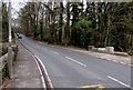
Stone edges of a road bridge over a stream, Ammanford
The bridge carries Dyffryn Road over Nant y Ci, http://www.geograph.org.uk/photo/4398676 a tributary of the River Loughor.
Image: © Jaggery
Taken: 11 Feb 2015
0.08 miles
5
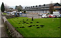
Molehills on a college campus, Ammanford
On the grass at the edge of the Coleg Sir Gâr (Carmarthenshire College) campus. http://www.geograph.org.uk/photo/4355072
Image: © Jaggery
Taken: 11 Feb 2015
0.09 miles
6
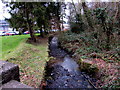
Stream flows past the western edge of the Coleg Sir G?r campus, Ammanford
The stream Nant y Ci is a tributary of the River Loughor (Afon Llwchwr in Welsh)
Image: © Jaggery
Taken: 11 Feb 2015
0.11 miles
7
Wet streaks on Rhodfa Frank, Ammanford
A street cleaning vehicle http://www.geograph.org.uk/photo/4345401 passed by a few seconds earlier.
Image: © Jaggery
Taken: 11 Feb 2015
0.11 miles
8
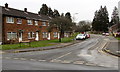
Rhodfa Frank, Gwyn Fryn Estate, Ammanford
On the north side of Station Road and Dyffryn Road. Rhodfa is Welsh for avenue.
Image: © Jaggery
Taken: 11 Feb 2015
0.11 miles
9
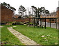
Community area in a suburban corner of Ammanford
On the corner of Rhodfa Frank and Heol Haydn.
Image: © Jaggery
Taken: 11 Feb 2015
0.11 miles
10
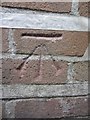
Ordnance Survey Cut Mark
This Ordnance Survey Cut Mark can be found on the NW Angle of Ammanford Technical College. It marks a point 33.2659m above mean sea level.
Image: © Adrian Dust
Taken: 20 Jun 2013
0.11 miles