IMAGES TAKEN NEAR TO
Dyffryn Road, AMMANFORD, SA18 3SY
Introduction
This page details the photographs taken nearby to Dyffryn Road, SA18 3SY by members of the Geograph project.
The Geograph project started in 2005 with the aim of publishing, organising and preserving representative images for every square kilometre of Great Britain, Ireland and the Isle of Man.

There are currently over 7.5m images from over14,400 individuals and you can help contribute to the project by visiting https://www.geograph.org.uk
Image Map
Images are licensed for reuse under creativecommons.org/licenses/by-sa/2.0
Notes
- Clicking on the map will re-center to the selected point.
- The higher the marker number, the further away the image location is from the centre of the postcode.
Image Listing (100 Images Found)
Images are licensed for reuse under creativecommons.org/licenses/by-sa/2.0
Image
Details
Distance
1
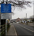
Instructions for drivers of large or slow vehicles, Ammanford
The blue notice is alongside Station Road on the approach to a level crossing. http://www.geograph.org.uk/photo/4354954 The notice defines a large vehicle and a slow vehicle and states that drivers of either must phone to get permission to cross the railway.
Image: © Jaggery
Taken: 11 Feb 2015
0.02 miles
2
Barriers rising at Station Road level crossing, Ammanford
After the Arriva Trains Wales train to Shrewsbury crossed Station Road, the barriers are ascending.
Image: © Jaggery
Taken: 11 Feb 2015
0.03 miles
3
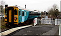
Departure from Ammanford railway station
An Arriva Trains Wales single-coach Class 153 Super Sprinter, fleet number 153303, crosses the Station Road level crossing at the northern end of Ammanford railway station. Next stop is Llandybie on the journey to Shrewsbury on the Heart of Wales Line.
Image: © Jaggery
Taken: 11 Feb 2015
0.03 miles
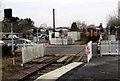
4
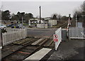
Keep Crossing Clear, Station Road, Ammanford
The level crossing is at the intersection of the Heart of Wales railway
and Station Road, a few metres north of Ammanford railway station.
Image: © Jaggery
Taken: 11 Feb 2015
0.03 miles
5
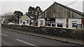
Mill Units, Station Road, Ammanford
Business units on the east bank of the River Loughor.
Image: © Jaggery
Taken: 11 Feb 2015
0.03 miles
6
Barriers descending across Station Road level crossing, Ammanford
The red and white barriers are being lowered across Station Road.
Viewed from Ammanford railway station, where a train to Shrewsbury is about to depart.
Image: © Jaggery
Taken: 11 Feb 2015
0.03 miles
7
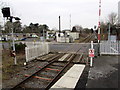
Station Road level crossing, Ammanford
Viewed from Ammanford railway station, where a train to Shrewsbury
is about to depart. The barriers will descend in a few seconds.
Image: © Jaggery
Taken: 11 Feb 2015
0.03 miles
8
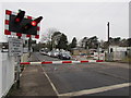
Red lights flashing, barriers down at Ammanford station level crossing
The barriers block Station Road traffic. A train is imminent.
Image: © Jaggery
Taken: 11 Feb 2015
0.03 miles
9
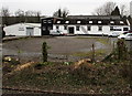
Cwmllwchwr Mill, Ammanford
Viewed from Ammanford railway station. The former mill on a bank of the River Loughor
is now in use as business/industrial units. One name in view is Amman uPVC.
Image: © Jaggery
Taken: 11 Feb 2015
0.03 miles
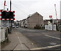
10
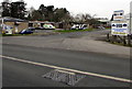
Southern end of Shands Road, Ammanford
Shands Road heads north away from Station Road near Ammanford railway station.
Image: © Jaggery
Taken: 11 Feb 2015
0.03 miles