IMAGES TAKEN NEAR TO
Pontardulais Road, AMMANFORD, SA18 3RE
Introduction
This page details the photographs taken nearby to Pontardulais Road, SA18 3RE by members of the Geograph project.
The Geograph project started in 2005 with the aim of publishing, organising and preserving representative images for every square kilometre of Great Britain, Ireland and the Isle of Man.

There are currently over 7.5m images from over14,400 individuals and you can help contribute to the project by visiting https://www.geograph.org.uk
Image Map
Images are licensed for reuse under creativecommons.org/licenses/by-sa/2.0
Notes
- Clicking on the map will re-center to the selected point.
- The higher the marker number, the further away the image location is from the centre of the postcode.
Image Listing (6 Images Found)
Images are licensed for reuse under creativecommons.org/licenses/by-sa/2.0
Image
Details
Distance
1
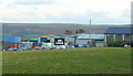
Mixture of businesses
This view, south-east of the A483 opposite the turn for Capel Hendre, takes in sheep pasture, workshops, and the Graig Fawr ridge in the background.
A very Welsh view - meant in the sincerest way.
Image: © Jonathan Billinger
Taken: 15 Oct 2008
0.08 miles
2
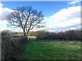
Field corner
A tree stands at the corner of a field near Tycroes.
Image: © Alan Hughes
Taken: 19 Nov 2018
0.11 miles
3
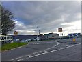
Road junction
Road junction near Tycroes Business Park
Image: © Alan Hughes
Taken: 19 Nov 2018
0.11 miles
4
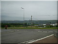
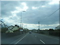
A483/B4297 road junction near Tycroes
The B4297 from Capel Hendre connects the A483 near Tycroes Business Park.
Image: © Martyn Harries
Taken: 27 Jul 2013
0.13 miles
6

Llwybr Llety Newydd Path
Cerddwyr yn dilyn llwybr cyhoeddus o Barc Busnes Tycroes at ffordd fach a elwir Heol Droeon Bach.
Walkers following a public footpath from Tycroes Business Park towards a minor thoroughfare known as Heol Droeon Bach (trans. road of little bends).
Image: © Alan Richards
Taken: 29 Nov 2009
0.24 miles