IMAGES TAKEN NEAR TO
Teglan Park, AMMANFORD, SA18 3RA
Introduction
This page details the photographs taken nearby to Teglan Park, SA18 3RA by members of the Geograph project.
The Geograph project started in 2005 with the aim of publishing, organising and preserving representative images for every square kilometre of Great Britain, Ireland and the Isle of Man.

There are currently over 7.5m images from over14,400 individuals and you can help contribute to the project by visiting https://www.geograph.org.uk
Image Map
Images are licensed for reuse under creativecommons.org/licenses/by-sa/2.0
Notes
- Clicking on the map will re-center to the selected point.
- The higher the marker number, the further away the image location is from the centre of the postcode.
Image Listing (2 Images Found)
Images are licensed for reuse under creativecommons.org/licenses/by-sa/2.0
Image
Details
Distance
1
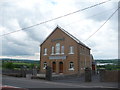
Bethesda Baptist chapel, Pontardulais Road, Tycroes
A large Baptist chapel on the A483 road through the village. In great nick.
Image: © Jeremy Bolwell
Taken: 4 Jun 2012
0.19 miles
2
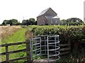
Llwybr Capel Bethesda Chapel Path
Gât fochyn ar lwybr cyhoeddus yn arwain tuag at Gapel Bethesda a'r A483(T).
A Kissing gate on a public footpath heading towards Bethesda Chapel and the A483(T).
Image: © Alan Richards
Taken: 13 Sep 2014
0.22 miles