IMAGES TAKEN NEAR TO
Tycroes, AMMANFORD, SA18 3PW
Introduction
This page details the photographs taken nearby to SA18 3PW by members of the Geograph project.
The Geograph project started in 2005 with the aim of publishing, organising and preserving representative images for every square kilometre of Great Britain, Ireland and the Isle of Man.

There are currently over 7.5m images from over14,400 individuals and you can help contribute to the project by visiting https://www.geograph.org.uk
Image Map (Loading...)


Getting Data...Please wait
Leaflet Map data © OpenStreetMap
Images are licensed for reuse under creativecommons.org/licenses/by-sa/2.0
Notes
- Clicking on the map will re-center to the selected point.
- The higher the marker number, the further away the image location is from the centre of the postcode.
Image Listing (8 Images Found)
Images are licensed for reuse under creativecommons.org/licenses/by-sa/2.0
Image
Details
Distance
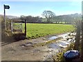
1
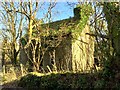
Ruined house
A ruined house stands alongside the road near Gelli Organ Farm.
Image: © Alan Hughes
Taken: 14 Feb 2019
0.11 miles
2
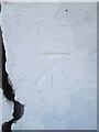
Ordnance Survey Cut Mark
This OS cut mark can be found on the milk stand for Gelli Organ Farm. It marks a point 98.188m above mean sea level.
Image: © Adrian Dust
Taken: 21 Sep 2014
0.13 miles
3
Milk Stand, Gelli Organ Farm
There is an Ordnance Survey cut mark on the NE face.
Image: © Adrian Dust
Taken: 21 Sep 2014
0.13 miles
4
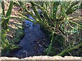
Stream through woodland
An unnamed stream flowing under the road and down towards the River Llwchwr.
Image: © Alan Hughes
Taken: 14 Feb 2019
0.15 miles
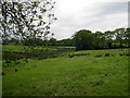
5
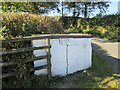
Bryn Awel Farm
Public footpath sign at entrance to Bryn Awel Farm.
Image: © Alan Hughes
Taken: 14 Feb 2019
0.21 miles
7

Ffrwd Llanedi Stream
Cerddwyr yn rhydio nant di-enw yn Llanedi. Mae'r llwybr yn arwain at Ffarm Pen Crug Isaf.
Walkers fording an apparent nameless stream in Llanedi. The path leads to Pen Crug Isaf Farm (trans. top of the mound).
Image: © Alan Richards
Taken: 29 Nov 2009
0.23 miles
8
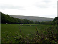
Sheep graze with Graig Fawr in background
Image: © John Duckfield
Taken: 20 May 2009
0.24 miles