IMAGES TAKEN NEAR TO
Fforest Fach, AMMANFORD, SA18 3PR
Introduction
This page details the photographs taken nearby to Fforest Fach, SA18 3PR by members of the Geograph project.
The Geograph project started in 2005 with the aim of publishing, organising and preserving representative images for every square kilometre of Great Britain, Ireland and the Isle of Man.

There are currently over 7.5m images from over14,400 individuals and you can help contribute to the project by visiting https://www.geograph.org.uk
Image Map
Images are licensed for reuse under creativecommons.org/licenses/by-sa/2.0
Notes
- Clicking on the map will re-center to the selected point.
- The higher the marker number, the further away the image location is from the centre of the postcode.
Image Listing (2 Images Found)
Images are licensed for reuse under creativecommons.org/licenses/by-sa/2.0
Image
Details
Distance
1
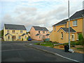
New housing at Tycroes
An extension to the Forestfach housing estate in the Loughor valley, south-west of Ammanford.
Nice pastel shades!
Image: © Jonathan Billinger
Taken: 15 Oct 2008
0.02 miles
2
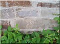
Ordnance Survey Cut Mark
This OS cut mark can be found on the wall north side of Tycroes Road. It marks a point 45.223m above mean sea level.
Image: © Adrian Dust
Taken: 14 Oct 2021
0.10 miles