IMAGES TAKEN NEAR TO
Tycanol, AMMANFORD, SA18 3JL
Introduction
This page details the photographs taken nearby to Tycanol, SA18 3JL by members of the Geograph project.
The Geograph project started in 2005 with the aim of publishing, organising and preserving representative images for every square kilometre of Great Britain, Ireland and the Isle of Man.

There are currently over 7.5m images from over14,400 individuals and you can help contribute to the project by visiting https://www.geograph.org.uk
Image Map
Images are licensed for reuse under creativecommons.org/licenses/by-sa/2.0
Notes
- Clicking on the map will re-center to the selected point.
- The higher the marker number, the further away the image location is from the centre of the postcode.
Image Listing (3 Images Found)
Images are licensed for reuse under creativecommons.org/licenses/by-sa/2.0
Image
Details
Distance
1
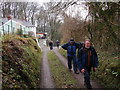
Llwybr Pentregwenlais Path
Cerddwyr yn dilyn llwybr o Bentregwenlias tuag at Banllyn.
Walkers following a footpath from Pentregwenlais (trans. main farm at white water stream) towards Pantllyn (lake hollow).
Image: © Alan Richards
Taken: 12 Feb 2012
0.12 miles
2
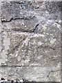
Ordnance Survey Cut Mark
This OS cut mark can be found on the remains of the wall of Bryngwenlais house to the south of the road. It marks a point 120.83m above mean sea level.
Image: © Adrian Dust
Taken: 24 Apr 2014
0.15 miles
3
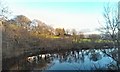
Pant-y-Llyn Turlough
The only turlough in mainland Britain, seen in winter. During the summer months, as the water table drops, this lake empties and is often completely dry.
Image: © Hywel Williams
Taken: 24 Dec 2014
0.23 miles