IMAGES TAKEN NEAR TO
Villiers Road, AMMANFORD, SA18 3HB
Introduction
This page details the photographs taken nearby to Villiers Road, SA18 3HB by members of the Geograph project.
The Geograph project started in 2005 with the aim of publishing, organising and preserving representative images for every square kilometre of Great Britain, Ireland and the Isle of Man.

There are currently over 7.5m images from over14,400 individuals and you can help contribute to the project by visiting https://www.geograph.org.uk
Image Map (Loading...)


Getting Data...Please wait
Leaflet Map data © OpenStreetMap
Images are licensed for reuse under creativecommons.org/licenses/by-sa/2.0
Notes
- Clicking on the map will re-center to the selected point.
- The higher the marker number, the further away the image location is from the centre of the postcode.
Image Listing (14 Images Found)
Images are licensed for reuse under creativecommons.org/licenses/by-sa/2.0
Image
Details
Distance
1
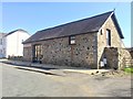
Head Candy
Converted barn now in use as a hairdressing salon.
Image: © Alan Hughes
Taken: 19 Apr 2018
0.09 miles
2
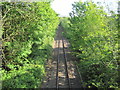
Parcyrhun Halt railway station (site), Carmarthenshire
Opened in 1936 by the Great Western Railway on the line from Llanelli to Llandeilo, this halt closed in 1955.
View south west towards Pantyffynnon and Llanelli.
Image: © Nigel Thompson
Taken: 17 May 2014
0.10 miles
3
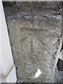
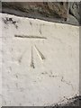
Ordnance Survey Cut Mark
This OS Cut Mark can found on the front of No5 New Road. It marks a point 33.2900m above mean sea level.
Image: © Adrian Dust
Taken: 13 Jul 2013
0.10 miles
5
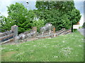
Welcome to Ammanford
A piece of sculpture graces the entrance to the town, in the shape of a wild boar with piglets.
Image: © Jeremy Bolwell
Taken: 4 Jun 2012
0.16 miles
6
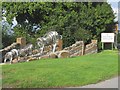
Gateway to Ammanford
A new installation on the A483 as it enters Ammanford from the south. The existing welcome sign can be seen to the right of shot.
The three metal pigs heading into town are actually "Twrch Trwyth" - wild boars - which are an adopted symbol of the Amman Valley.
Close up of sculpture: Image
Local news story: http://www.southwalesguardian.co.uk/news/ammanfordnews/3226521.Development_is_a_total_boar/
Image: © Nigel Davies
Taken: 2 Aug 2008
0.17 miles
7
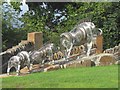
Detail of Twrch Trwyth sculpture
Tony Woodman's sculpture of three wild boars. Detail from Image
Image: © Nigel Davies
Taken: 2 Aug 2008
0.17 miles
8
Ordnance Survey Cut Mark
This OS Cut Mark can be found on the front of No93 Wind Street. It marks a point 33.9331m above mean sea level.
Image: © Adrian Dust
Taken: 28 Jul 2013
0.17 miles
9
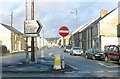
Wind Street, Ammanford (Recreated)
This is a recreation of the 1965 photo from the Frith collection here: http://www.francisfrith.com/search/wales/dyfed/ammanford/photos/ammanford_A186034.htm
The view is looking northeast towards the town centre along Wind Street from its junction with the road to Pantyffynnon.
Image: © Nigel Davies
Taken: 6 Jan 2007
0.18 miles
10
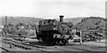
GW/WR Pannier Tank on Rhos Colliery branch, at Penybanc Colliery, near Pantyfynnon
View SE from the A483 road, west of Pantyfynnon on the Llandilo - Pontadulais/Llanelly (ex-GW&LNW) section of the Central Wales Line. The apparently wooded hill on the right has since disappeared, as it was a colliery tip since landscaped. In the distance are the 900-1,000 ft. mountains on the far side of the River Loughor, Mynydd Bettws and Graig fawr. The locomotive is 'modern' GW-design '1600' class 0-6-0T No. 1655 (built 1/55, withdrawn 7/65).
Image: © Ben Brooksbank
Taken: 1 Jun 1962
0.20 miles