IMAGES TAKEN NEAR TO
Ffordd Y Rhyd, AMMANFORD, SA18 3FB
Introduction
This page details the photographs taken nearby to Ffordd Y Rhyd, SA18 3FB by members of the Geograph project.
The Geograph project started in 2005 with the aim of publishing, organising and preserving representative images for every square kilometre of Great Britain, Ireland and the Isle of Man.

There are currently over 7.5m images from over14,400 individuals and you can help contribute to the project by visiting https://www.geograph.org.uk
Image Map (Loading...)


Getting Data...Please wait
Leaflet Map data © OpenStreetMap
Images are licensed for reuse under creativecommons.org/licenses/by-sa/2.0
Notes
- Clicking on the map will re-center to the selected point.
- The higher the marker number, the further away the image location is from the centre of the postcode.
Image Listing (10 Images Found)
Images are licensed for reuse under creativecommons.org/licenses/by-sa/2.0
Image
Details
Distance
1
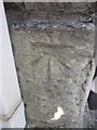
Ordnance Survey Cut Mark
This OS Cut Mark can found on the front of No5 New Road. It marks a point 33.2900m above mean sea level.
Image: © Adrian Dust
Taken: 13 Jul 2013
0.11 miles
2
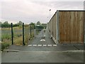
North gate of Pantyffynnon to Ammanford cycle path
This is the vehicle-proof gate at the Ammanford end of the newly opened section of the Amman Valley cycleway. The fence in the photo is part of the loading bay behind the town's Tesco.
Image: © Nigel Davies
Taken: 27 Jul 2013
0.15 miles
3
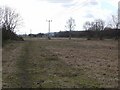
View of the Amman river bank
This part of a field in Ammanford alongside the river has been cleared and markers put in ready for development.
Image: © John Phoenix
Taken: 13 Mar 2007
0.17 miles
4
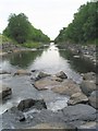
The River Amman
This is the view south downstream between Betws and Pantyffynon
Image: © Nigel Davies
Taken: 21 Jun 2005
0.18 miles
5
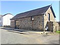
Head Candy
Converted barn now in use as a hairdressing salon.
Image: © Alan Hughes
Taken: 19 Apr 2018
0.18 miles
6
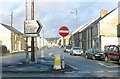
Wind Street, Ammanford (Recreated)
This is a recreation of the 1965 photo from the Frith collection here: http://www.francisfrith.com/search/wales/dyfed/ammanford/photos/ammanford_A186034.htm
The view is looking northeast towards the town centre along Wind Street from its junction with the road to Pantyffynnon.
Image: © Nigel Davies
Taken: 6 Jan 2007
0.18 miles
7
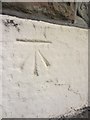
Ordnance Survey Cut Mark
This OS Cut Mark can be found on the front of No93 Wind Street. It marks a point 33.9331m above mean sea level.
Image: © Adrian Dust
Taken: 28 Jul 2013
0.19 miles
8
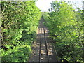
Parcyrhun Halt railway station (site), Carmarthenshire
Opened in 1936 by the Great Western Railway on the line from Llanelli to Llandeilo, this halt closed in 1955.
View south west towards Pantyffynnon and Llanelli.
Image: © Nigel Thompson
Taken: 17 May 2014
0.19 miles
10
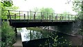
Disused rail bridge over the River Loughor
A significant rail line branched off from the Heart of Wales line here and followed the Fferws brook upstream to some small collieries.
The bridge is now reduced to half width but is still crossable and is the only way to access the small area of land between the river and the main line here: Image
Image: © Nigel Davies
Taken: 20 May 2012
0.25 miles