IMAGES TAKEN NEAR TO
Clos Fferws, AMMANFORD, SA18 3BL
Introduction
This page details the photographs taken nearby to Clos Fferws, SA18 3BL by members of the Geograph project.
The Geograph project started in 2005 with the aim of publishing, organising and preserving representative images for every square kilometre of Great Britain, Ireland and the Isle of Man.

There are currently over 7.5m images from over14,400 individuals and you can help contribute to the project by visiting https://www.geograph.org.uk
Image Map
Images are licensed for reuse under creativecommons.org/licenses/by-sa/2.0
Notes
- Clicking on the map will re-center to the selected point.
- The higher the marker number, the further away the image location is from the centre of the postcode.
Image Listing (2 Images Found)
Images are licensed for reuse under creativecommons.org/licenses/by-sa/2.0
Image
Details
Distance
1
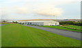
Industrial units at Parc Hendre
The post-industrial South Wales economy is based on facilities like these.
Image: © Jonathan Billinger
Taken: 15 Oct 2008
0.18 miles
2
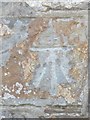
Ordnance Survey Cut Mark
This Ordnance Survey Cut Mark can be found on the front of No144 Hendre Road. It marks a point 99.0800m above mean sea level.
Image: © Adrian Dust
Taken: 9 Jun 2013
0.22 miles