IMAGES TAKEN NEAR TO
Wernddu Road, AMMANFORD, SA18 2UP
Introduction
This page details the photographs taken nearby to Wernddu Road, SA18 2UP by members of the Geograph project.
The Geograph project started in 2005 with the aim of publishing, organising and preserving representative images for every square kilometre of Great Britain, Ireland and the Isle of Man.

There are currently over 7.5m images from over14,400 individuals and you can help contribute to the project by visiting https://www.geograph.org.uk
Image Map (Loading...)


Getting Data...Please wait
Leaflet Map data © OpenStreetMap
Images are licensed for reuse under creativecommons.org/licenses/by-sa/2.0
Notes
- Clicking on the map will re-center to the selected point.
- The higher the marker number, the further away the image location is from the centre of the postcode.
Image Listing (4 Images Found)
Images are licensed for reuse under creativecommons.org/licenses/by-sa/2.0
Image
Details
Distance
1
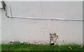
Ordnance Survey Cut Mark
This OS cut mark can be found on Abercenfi Farmhouse. It marks a point 79.130m above mean sea level.
Image: © Adrian Dust
Taken: 14 Oct 2021
0.08 miles
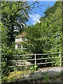
2
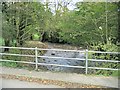
Bridge over the Loughor at Cwmllwchwr Mill
On the other side of this bridge is a residence that was formerly a mill on the river.
Image: © Nigel Davies
Taken: 30 Oct 2005
0.20 miles
4
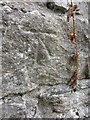
Ordnance Survey Cut Mark
This OS cut mark can be found on an outbuilding of Cwm Llwchwr Farm. It marks a point 89.9481m above mean sea level.
Image: © Adrian Dust
Taken: 24 Aug 2013
0.24 miles