IMAGES TAKEN NEAR TO
Derwydd Road, AMMANFORD, SA18 2TS
Introduction
This page details the photographs taken nearby to Derwydd Road, SA18 2TS by members of the Geograph project.
The Geograph project started in 2005 with the aim of publishing, organising and preserving representative images for every square kilometre of Great Britain, Ireland and the Isle of Man.

There are currently over 7.5m images from over14,400 individuals and you can help contribute to the project by visiting https://www.geograph.org.uk
Image Map (Loading...)


Getting Data...Please wait
Leaflet Map data © OpenStreetMap
Images are licensed for reuse under creativecommons.org/licenses/by-sa/2.0
Notes
- Clicking on the map will re-center to the selected point.
- The higher the marker number, the further away the image location is from the centre of the postcode.
Image Listing (4 Images Found)
Images are licensed for reuse under creativecommons.org/licenses/by-sa/2.0
Image
Details
Distance
1
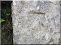
Ordnance Survey Cut Mark
This OS cut mark can be found on an outbuilding of Blaengweche Farm. It marks a point 147.8506m above mean sea level.
Image: © Adrian Dust
Taken: 24 Aug 2013
0.07 miles
3
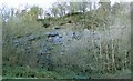
Long abandoned quarry near Blaengweche
Part of the disused quarry wall is just visible behind all the trees that have grown here.
Image: © Nigel Davies
Taken: 13 Nov 2005
0.20 miles
4
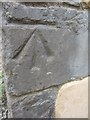
Ordnance Survey Cut Mark
This OS cut mark can be found on a building at Carreg Yr Ogof. It marks a point 145.3382m above mean sea level.
Image: © Adrian Dust
Taken: 22 Jul 2013
0.21 miles