IMAGES TAKEN NEAR TO
Heol Y Mynydd, AMMANFORD, SA18 2SE
Introduction
This page details the photographs taken nearby to Heol Y Mynydd, SA18 2SE by members of the Geograph project.
The Geograph project started in 2005 with the aim of publishing, organising and preserving representative images for every square kilometre of Great Britain, Ireland and the Isle of Man.

There are currently over 7.5m images from over14,400 individuals and you can help contribute to the project by visiting https://www.geograph.org.uk
Image Map
Images are licensed for reuse under creativecommons.org/licenses/by-sa/2.0
Notes
- Clicking on the map will re-center to the selected point.
- The higher the marker number, the further away the image location is from the centre of the postcode.
Image Listing (3 Images Found)
Images are licensed for reuse under creativecommons.org/licenses/by-sa/2.0
Image
Details
Distance
1
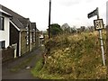
Footpath to Bryncyffon
A footpath starts here, goes past the old school on the left and skirts Pen y Cwar on its way to Bryncyffon.
Image: © Alan Hughes
Taken: 17 Dec 2018
0.03 miles
2
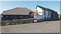
Yr Hen Ysgol (The Old School)
Yr Hen Ysgol (Welsh for The Old School) is now a private residence, art studio and recently opened coffee shop. Image is an image of the old school shortly before it closed, taken 15 years prior to this one.
Image: © Hywel Williams
Taken: 13 Jun 2021
0.04 miles
3
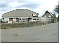
Garnswllt School
The school (and the whole village) is covered in "save our school" slogans. Garnswllt is a small community on the distant edge of the City & County of Swansea and the school is probably facing closure.
Image: © Nigel Davies
Taken: 16 Apr 2006
0.05 miles