IMAGES TAKEN NEAR TO
Garnswllt, AMMANFORD, SA18 2SD
Introduction
This page details the photographs taken nearby to SA18 2SD by members of the Geograph project.
The Geograph project started in 2005 with the aim of publishing, organising and preserving representative images for every square kilometre of Great Britain, Ireland and the Isle of Man.

There are currently over 7.5m images from over14,400 individuals and you can help contribute to the project by visiting https://www.geograph.org.uk
Image Map
Images are licensed for reuse under creativecommons.org/licenses/by-sa/2.0
Notes
- Clicking on the map will re-center to the selected point.
- The higher the marker number, the further away the image location is from the centre of the postcode.
Image Listing (2 Images Found)
Images are licensed for reuse under creativecommons.org/licenses/by-sa/2.0
Image
Details
Distance
1
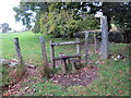
Llwybr ger Pentre-t?n / Path near Pentre-t
Llwybr cyhoeddus yn mynd i gyfeiriad Ffarm Llety'r Ffwlbert.
A public footpath heading in the direction of Llety Ffwlbert Ffarm (trans. dwelling of the polecat).
Image: © Alan Richards
Taken: 2 Oct 2020
0.16 miles
2
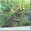
Mountain Stream on the road from Garnswllt to Pontardulais
This is the view upstream from the road bridge.
Image: © Nigel Davies
Taken: 7 Aug 2005
0.21 miles